This man divided India for 40,000 rupees and caused all Indo-Pak wars | Story of the most unscientific border map

Cyril Radcliffe caused Partition of India and Kashmir conflict because of his map. Pahalgam terror Indo-Pak war Trending | World | India News | South Asia | Pakistan
Pahalgam terror attack leads to possible Indo-Pak war, but Cyril Radcliffe caused all India-Pakistan conflicts: I watched Chhaava, on Chhatrapati Sambhaji Maharaj who fought Aurangzeb, on Netflix, days after the Bollywood film caused calls to dig up and remove the grave of the Mughal emperor, the villain of the piece. Revisionist views of history, seeking revenge for wrongs done three or four centuries ago, were at the heart of such demands. But if one were to indeed revisit history and think about who wronged us in the context of the possible fifth Indo-Pakistan war over the Pahalgam terror attack, then perhaps the story of one man - from just 77 years ago, not centuries - needs to be dug up: Cyril Radcliffe, whose name adorns the Radcliffe Line, the international boundary of India and Pakistan.
Because it is the Radcliffe Line, arguably the most unscientific international boundary ever drawn on a map, that led to the Partition of India, millions of deaths, starvation, massacres, rapes, and the past four Indo-Pak wars. It is the fountainhead of the so-called Kashmir issue. It is important that we, particularly the younger generations, know about the atrocities committed on the subcontinent by the British colonial rulers, of whom Radcliffe was a servant, leaving generations to bear the brunt.

Who was Cyril Radcliffe?
Cyril John Radcliffe, the 1st Viscount Radcliffe was a British lawyer. Born in 1899, he studied at Haileybury College. He did an honours degree from New College, Oxford in classics, philosophy, and ancient history, the course known as 'literae humaniores'. He was sent from Britain to draw the map because the colonial rulers thought that he would be 'neutral'. For context, his mission came amid Britain's hasty plans to withdraw from colonies like India, as it was drowning under debt due to the ravages of World War II (1939-1945).
Was Cyril Radcliffe really qualified to draw the India Pakistan boundary?
)
At least 3 killed in mass shooting at Idaho restaurant, shocking video of gunman open firing with AR-style rifle surfaces
&im=FitAndFill=(700,400))
Meet top 5 batters in latest ICC Test rankings 2026 - check who sits at the top
)
The Royals enter the Doctor Who universe: King Charles and Queen Camilla beam into Commonwealth Games in TARDIS
&im=FitAndFill=(700,400))
Why Russian tanks are much lighter compared to US tanks
&im=FitAndFill=(700,400))
Meet top 5 openers with fastest ODI centuries, check who tops list
)
US offers $15mn reward to dismantle alleged IRGC drone funding network
&im=FitAndFill=(700,400))
From Tom Holland-Zendaya to Blake Lively-Ryan Reynolds: Actors who met on sets and fell in love and married
)
Ancient DNA reveals mix of Tibetan and North Indian ancestry
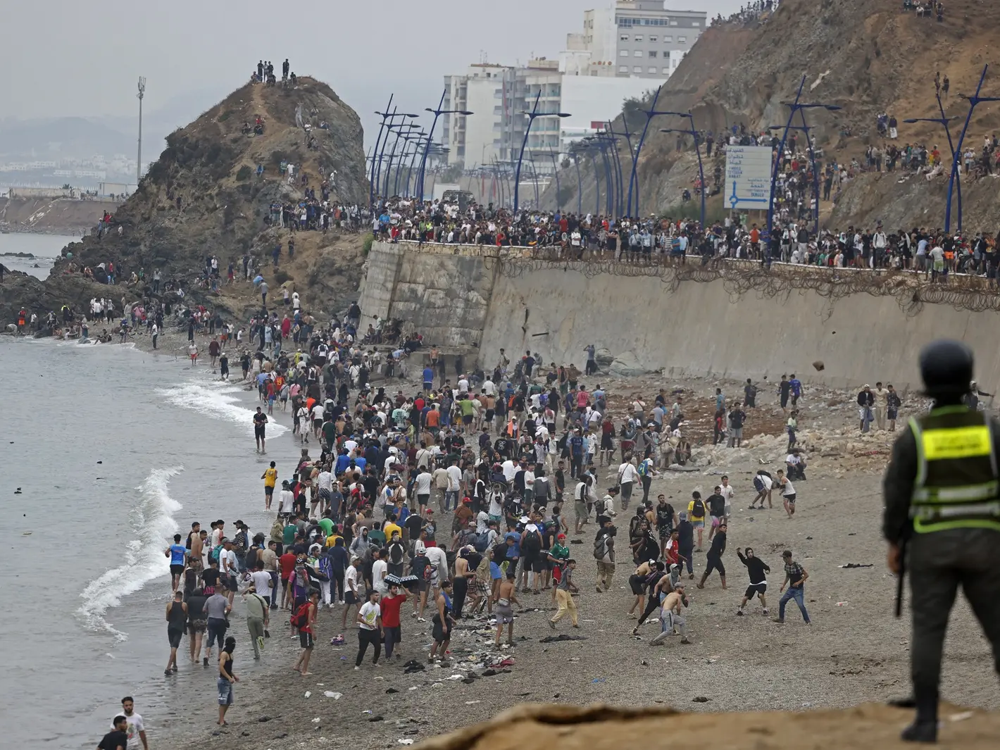)
60,000 migrants from Morocco flood Spain's Ceuta, EU calls influx unacceptable, Trump warns US
)
Delhi Consumer Court fines Indian Railways Rs 25,000 for making RAC passengers share one blanket
)
German anatomist 'Dr Death's' family to grant his creepy last wish
&im=FitAndFill=(700,400))
How often does an S-400 need maintenance?
&im=FitAndFill=(700,400))
Why Russian fighter pilots wear blue flight suits compared to US pilots
)
Hrithik Roshan reacts to 'sorry Hrithik' trend, Kangana Ranaut slams him, mentions Saba Azad: 'You are in a committed relationship'
&im=FitAndFill=(700,400))
'Fifth-generation fighters': Can the S-400 shoot down an F-35?
&im=FitAndFill=(700,400))
How the S-400 turns the sky into a no-fly zone
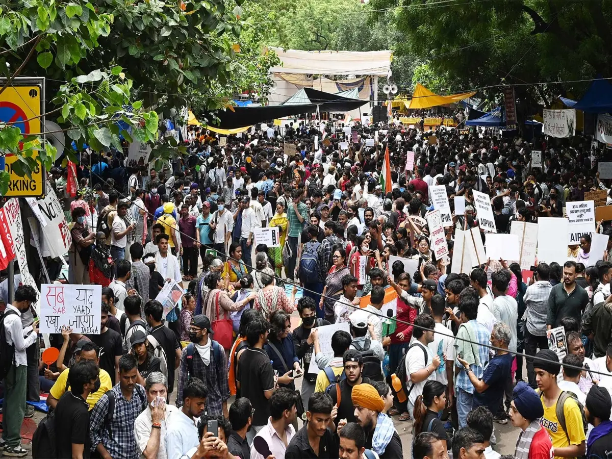)
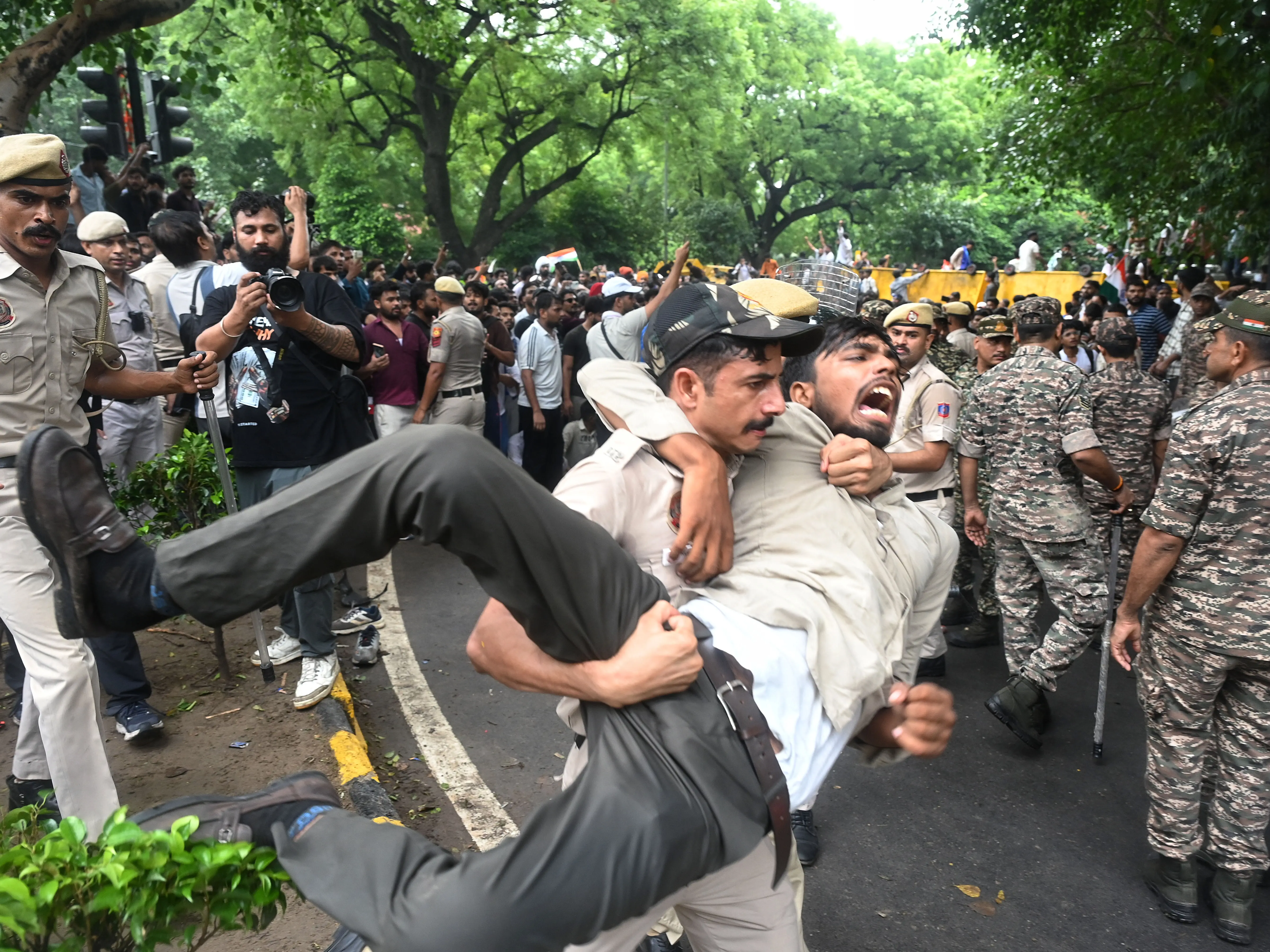
Who is Ruchika Singh, booked for using foul language against PM Modi at Jantar Mantar protests?
)
India avoids higher US tariff, secures lower 10% rate. Here's how
)
India-China reopen Nathu La route, reviving historic Silk Route trade corridor
)
NEET Protests riddled with misinformation? Delhi Police blocks 480 Pakistan-based handles spreading 'fake news' since Operation Sindoor
&im=FitAndFill=(700,400))
Meet top 5 bowlers in latest ICC Test rankings 2026 - check who sits at the top
&im=FitAndFill=(700,400))
August 2025 movie release calendar: Toxic, Batwara 1947, Awarapan 2 and all big-ticket films hitting theatres
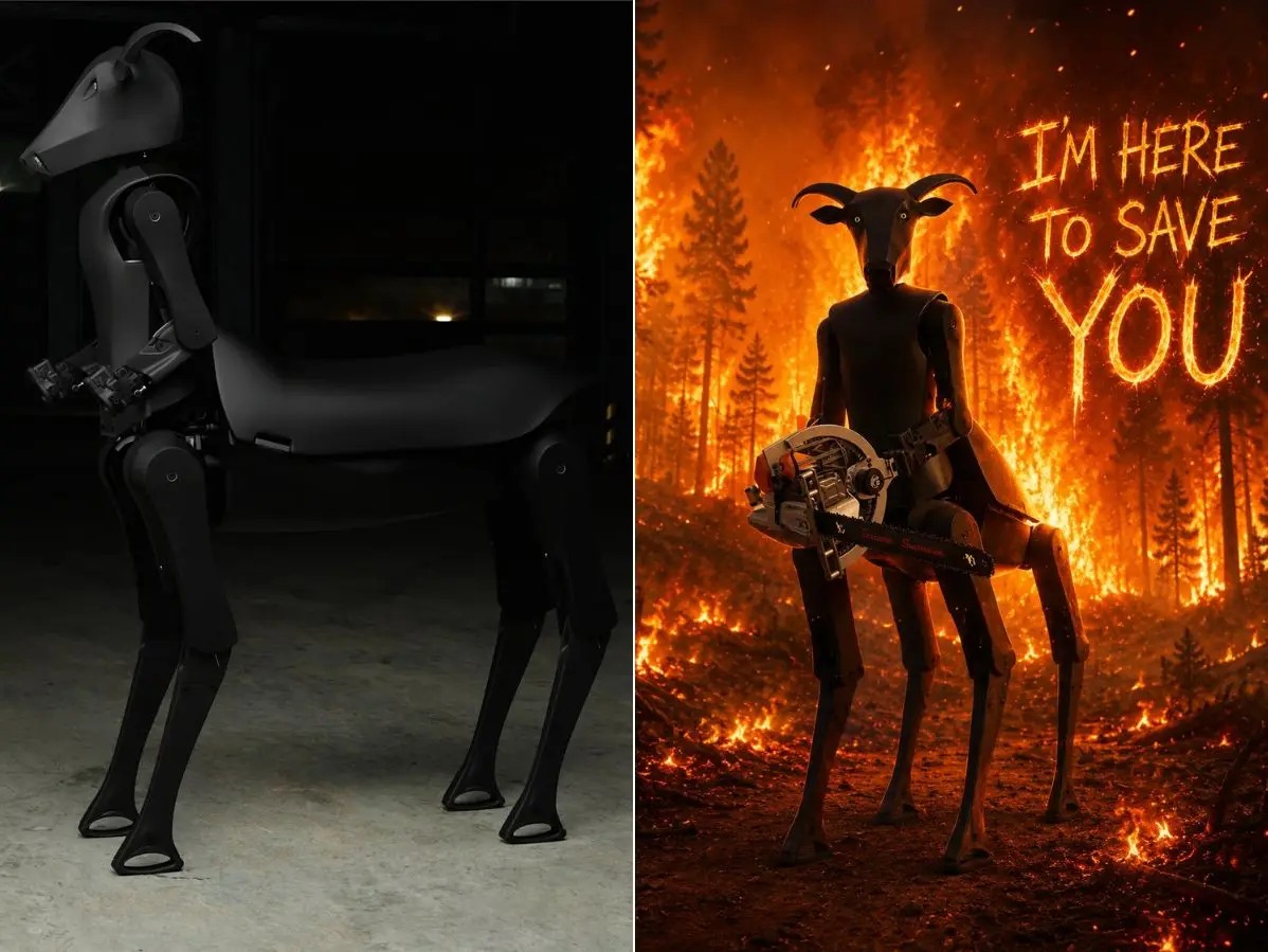)
‘Satanic’ chainsaw-wielding rescue bot leaves internet divided: ‘Those eyes are horrifying’
)
Kim Kardashian shares sweet moment with boyfriend Lewis Hamilton during summer vacation
&im=FitAndFill=(700,400))
Meet top 5 batters in latest ICC ODI rankings 2026 - check who sits at the top
)
Did Araghchi agree to open Hormuz to stop Trump’s planned US strikes on Iran? What we know
)
Ariana Grande's Petal video fuels debate as fans voice concern over her appearance
&im=FitAndFill=(700,400))
Why are iPhones so expensive compared to Android phones?
)
Trump says Iranian school bombing photos could be AI-generated - 'I don’t think...'
)
Have 7,000 Karnataka students tested positive for HIV? Here's the truth
)
Trump, Putin kissing in Amsterdam? Pride parade’s ‘couple’ goes viral | WATCH
&im=FitAndFill=(700,400))
Why Russian jets use heavier steel compared to US jets
)
‘US is locked and loaded’: Trump calls off Iran attack but sets THESE conditions
)
Nick Jonas' July photo dump featuring Priyanka Chopra and Malti Marie leaves fans gushing over family bond
)
'I was almost trafficked in Paris,' says Australian woman, shares terrifying ordeal - 'I am on the black market'
)
Lift accident? Maintenance, builders & makers are ALL liable now, rules Supreme Court: 3 major regulations | WION Decodes
Absolutely not, as his career was focused on law, culminating in roles like Law Lord and chairman of public inquiries.He had no expertise in geography or demographics of any place, let alone India.
Cyril Radcliffe had no formal qualifications in cartography or map-making, and mostly relied on census data done in the past by British rulers - which was also neither sufficient nor neutral - to draw the international boundary.
And remember that the concept of census itself a controversial one. There are arguments that, coming from a largely monotheist nation, British colonialists found it difficult to comprehend the ethnic, racial and religious diversity of the colonies, and used the census as a way to govern. Again, some argue that the census itself was part of the larger 'divide and rule' policy of the British.
How did Radcliffe become the man who made the international border of India and Pakistan?
Radcliffe was appointed to chair the Boundary Commissions for India’s 1947 partition as he was seen to be a neutral figure. The thought at the time appears to have been that, in the middle of demands by both Hindu and Muslim leaders on how to carve Pakistan out of India, someone with no historical baggage could be a better choice.
How did Radcliffe draw the India-Pakistan map?
As mentioned, Radcliffe’s process heavily relied upon outdated census data, maps, and limited input from the Boundary Commissions for Punjab and Bengal. These commissions had four representatives each, two from the Indian National Congress and two from the Muslim League. It is understood that conflicting agendas of their leaders led to stalling of the boundary drawing.
Radcliffe drew the border by merging the census data and previous maps. He simply looked at the district level data for population, and considered only which community was the numerical majority in specific areas. Remember that these were tens of thousands of villages and towns where Hindus, Muslims, Christians and other communities lived side by side for centuries. But the boundary line drawn by Radcliffe cut through real geographical features, even hills, rivers and mountains.
Radcliffe had a tough task, a tight deadline, and he chose the easiest way out
British Viceroy Lord Mountbatten was given around five months to make the transition from British India to independent India. He brought it down to just five weeks, even keeping a 'days to go' calendar behind his desk.
In total, Radcliffe was tasked with dividing some 175,000 square miles with 88 million people based on which religion was numerically the majority.
He reportedly considered factors like natural boundaries, irrigation systems, and communication lines, but in the end, clearly failed in accounting for everything. The rivers that run through both India and Pakistan is a case in point. But that's something he couldn't have helped.
Radcliffe worked from Shimla, the winter capital of the British, with no time for conducting field surveys on the ground, due to the tight deadline.
How Radicllife rushed through his decisions
There were points in the boundary drawing process where Radcliffe took his own, unilateral decisions amid bickering among political leaders on which part should go to India and which to Pakistan.
The Radcliffe Line was finalised by 9August 1947, just days ahead of the August 15 Independence Day. But a formal announcement of the boundary was made two days later, on 17 August, to avoid clashing with independence celebrations.
And that's when all hell broke loose.
The outcome of Radcliffe Line: World's largest forced migration
The announcement of the boundary was followed by the actual Partition of India.Hindus living on the other side of this border was given the choice to cross into India. And Muslims had the choice to go to Pakistan. I said 'choice' here, but in actual practice, tens of thousands of villagers had no choice but to leave everything and move to either India or Pakistan, due to fears of attacks from the other community.
The hasty process of by which Radcliffe drew the international boundary, in essence, triggered the mass migrations and violence of Partition, the largest forced displacement of humans ever, in which millions died.
Radicliffe had never visited India, and stayed only 35 days to cut a line through the map
Radcliffe arrived in India on 8 July 1947 and left shortly after submitting his partition map.All in all, he is reported to have spent only 35 days in the country.
He never returned.
Did he regret his decision?
Yes, if we go by the records of his subsequent life.
Amid looming war threat, Jammu and Kashmir schools train students on survival, evacuation
Radcliffe was reportedly haunted by the partition’s consequences.He eventually refused to accept his 40,000 rupees fee for his work in drawing the map that partitioned India, and burned the relevant papers.
Is Radcliffe the only person to blame?
No. Lord Mountbatten, and the leaders of India and what became Pakistan at the time, are equally responsible. Muhammad Ali Jinnah, the staunch advocate of two-nation theory was vehement in establishing the Muslim nation of Pakistan, and argued for every inch of land. And Kashmir, where a Hindu king ruled over a Muslim-majority population, was among the most contested.
With the five-week timeframe dictated by Mountbatten’s accelerated independence schedule,Radcliffe could not conduct thorough assessments.
'Privileged partnership not subject to...' says Russia as it calls for de-escalation between India and Pakistan
He was mostly reliant on secondary sources, past British census data and non-neutral maps of India.
And he put speed over precision.
Radcliffe drew a squiggly line on a map, and reshaped a subcontinent.
And millions suffered, starting from the Partition to the four wars between India and Pakistan.