Why Nepal’s flash flood is a warning for South Asia: Explained

&imwidth=600&imheight=450&format=webp&quality=medium "Why Nepal’s flash flood is a warning for South Asia: Explained")
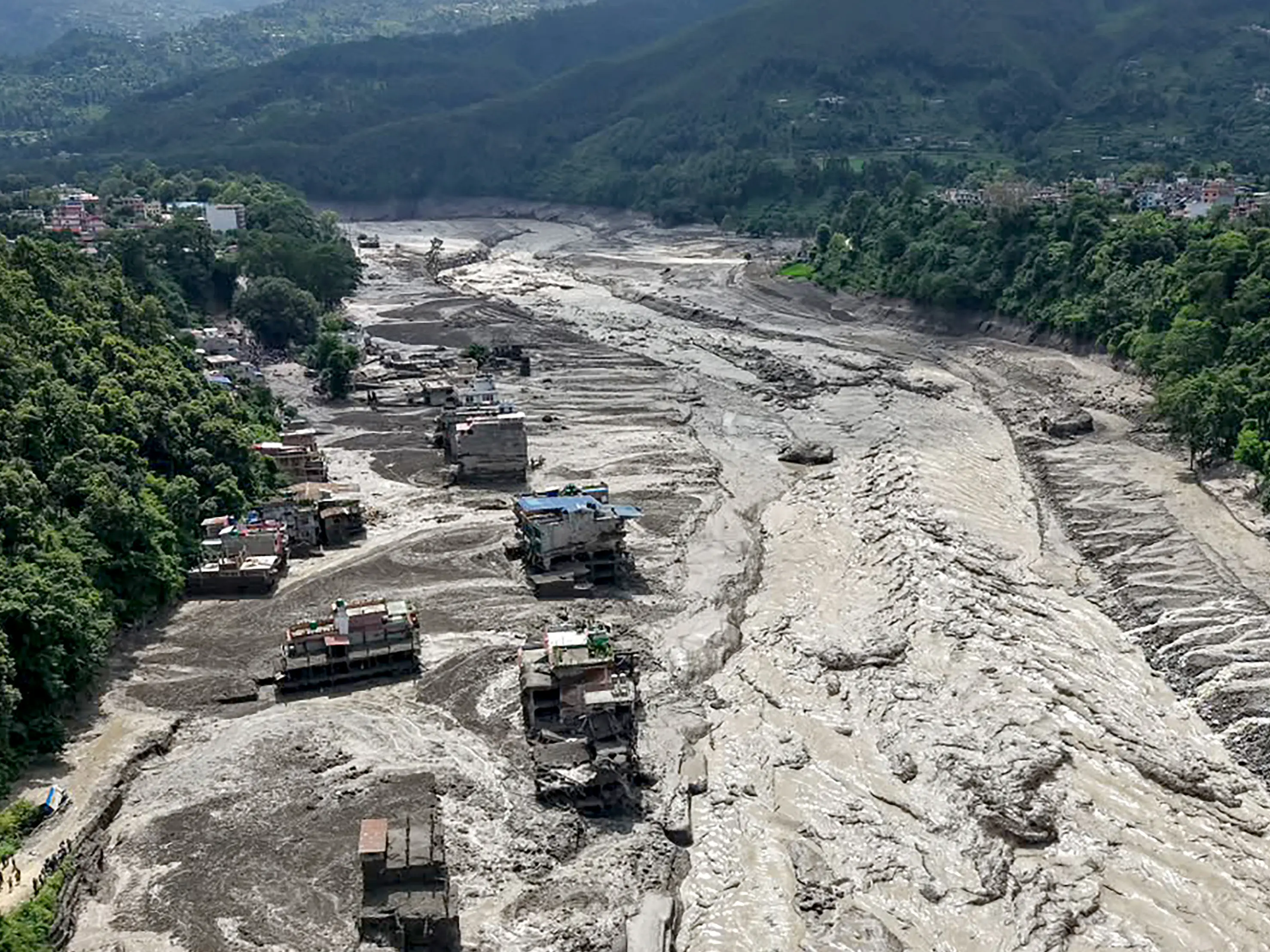
This aerial view shows houses laying partially submerged in muddy water along a riverside after flash floods at Trishuli Bazar in Nepal's Nuwakot district on August 26, 2026. Photograph: (AFP)
At Galchchi, water levels in the Trishuli reportedly rose by as much as nine metres in just 30 minutes. Several monitoring stations were damaged or washed away. That single statistic explains why the region needs a fundamentally different approach to disaster preparedness.
An ice-rock avalanche, a warming Himalaya and a nine-metre rise in river levels in just 30 minutes show why disaster management can no longer stop at national borders. The devastating flash floods that swept through central Nepal on August 26 are more than a Himalayan disaster. They are a warning for the entire South Asian region. More than 160 people have been reported dead, and nearly 500 remain missing, including 133 Indians, according to early assessments. The floods devastated settlements, washed away bridges, and damaged hydropower infrastructure across the affected areas.
The speed of the disaster is particularly alarming. The flood wave travelled through the Bhote Koshi and Trishuli river systems, leaving little time for communities to respond. At Galchchi, water levels in the Trishuli reportedly rose by as much as nine metres in just 30 minutes. Several monitoring stations were damaged or washed away. That single statistic explains why the region needs a fundamentally different approach to disaster preparedness.
What triggered the Nepal flash flood?
Scientists are still investigating the precise sequence of events. But experts from the International Centre for Integrated Mountain Development (ICIMOD) say an ice-rock avalanche from a high-altitude area is the likely trigger. Preliminary assessments based on satellite information, videos and reports from affected areas indicate that a large volume of ice and rock debris may have entered the Lende Khola, a tributary of the Bhote Koshi. This could have generated a sudden and powerful surge carrying water, sediment and huge boulders downstream.
The event's extraordinary speed is consistent with such a high-energy mountain hazard. Water levels at Galchchi rose by nine metres within half an hour, while levels at Malekhu reportedly increased by about seven metres over a similar period. There are also reports of seismic activity around the time of the event, and scientists are examining whether an earthquake may have contributed to the instability. Other possible mechanisms, including glacial processes and temporary river blockages, are also being investigated. It is therefore too early to attribute the disaster to a single cause with absolute certainty.
Trending Stories
&im=FitAndFill=(700,400)&imwidth=280&imheight=210&format=webp&quality=medium)
&imwidth=280&imheight=210&format=webp&quality=medium)
&imwidth=280&imheight=210&format=webp&quality=medium)
&imwidth=280&imheight=210&format=webp&quality=medium)
&imwidth=280&imheight=210&format=webp&quality=medium)
&imwidth=280&imheight=210&format=webp&quality=medium)
&imwidth=280&imheight=210&format=webp&quality=medium)
&imwidth=280&imheight=210&format=webp&quality=medium)
&imwidth=280&imheight=210&format=webp&quality=medium)
&imwidth=280&imheight=210&format=webp&quality=medium)
&imwidth=280&imheight=210&format=webp&quality=medium)
&imwidth=280&imheight=210&format=webp&quality=medium)
&imwidth=280&imheight=210&format=webp&quality=medium)
&imwidth=280&imheight=210&format=webp&quality=medium)
&imwidth=280&imheight=210&format=webp&quality=medium)
&imwidth=280&imheight=210&format=webp&quality=medium)
&imwidth=280&imheight=210&format=webp&quality=medium)
&imwidth=280&imheight=210&format=webp&quality=medium)
&imwidth=280&imheight=210&format=webp&quality=medium)
&imwidth=280&imheight=210&format=webp&quality=medium)
&imwidth=280&imheight=210&format=webp&quality=medium)
&im=FitAndFill=(700,400)&imwidth=280&imheight=210&format=webp&quality=medium)
&imwidth=280&imheight=210&format=webp&quality=medium)
&imwidth=280&imheight=210&format=webp&quality=medium)
&imwidth=280&imheight=210&format=webp&quality=medium)
&imwidth=280&imheight=210&format=webp&quality=medium)
&imwidth=280&imheight=210&format=webp&quality=medium)
&imwidth=280&imheight=210&format=webp&quality=medium)
&im=FitAndFill=(700,400)&imwidth=280&imheight=210&format=webp&quality=medium)
&imwidth=280&imheight=210&format=webp&quality=medium)
&imwidth=280&imheight=210&format=webp&quality=medium)
&imwidth=280&imheight=210&format=webp&quality=medium)
What is increasingly clear, however, is that the cryosphere — the world's frozen regions of glaciers, snow and ice — is becoming a critical part of disaster-risk management.
Is the damage confined to one country?
The destruction has been severe. Villages and settlements were inundated, roads and bridges swept away and hydropower projects damaged. At least 19 bridges and around 40 km of roads were reported damaged in Nepal as rescue operations continued.
But the bigger concern is geographical.
Himalayan rivers cross political boundaries. The Trishuli enters India as the Gandak, eventually flowing through the densely populated plains of Bihar and Uttar Pradesh. A sudden upstream event can therefore become a downstream emergency thousands of people away from its origin.
This is why Bihar and Uttar Pradesh were placed on alert following the Nepal disaster. The safety of communities downstream depends partly on what happens upstream — often in terrain that is difficult to monitor in real time.
Why Nepal, India, and China need to work together?
The Himalayas are a shared geography, but disaster-management systems remain largely national. That needs to change. Nepal, India, and China should establish stronger mechanisms for real-time sharing of rainfall, river-flow, seismic, glacier, and satellite data. If an ice-rock avalanche or glacial lake event occurs in a remote high-altitude area, downstream authorities should receive an alert within minutes — not after floodwaters have already entered populated areas.
Can technology make this increasingly possible?
High-resolution satellites can monitor changes in glaciers and unstable slopes. Automated river gauges can detect sudden changes in water levels. Seismic sensors can identify disturbances associated with landslides and avalanches. Weather radar can track extreme precipitation. Artificial intelligence can combine these datasets and identify abnormal patterns much faster than conventional monitoring systems.
The next step should be to connect these technologies across borders.
A Himalayan Early Warning Network could integrate satellite imagery, ground sensors, river gauges, weather forecasts and AI-based risk models. Alerts could then be pushed directly to disaster-management authorities and vulnerable communities through cell broadcast, SMS, sirens and local communication networks. The objective should be simple: detect upstream, alert downstream and act before the flood arrives.
Is Climate change making the risk harder to manage?
It would be scientifically incorrect to say that climate change alone caused this particular flash flood. Mountain disasters are often produced by multiple factors — geology, earthquakes, rainfall, glacier instability and human settlement patterns. But climate change is changing the background conditions.
The Himalayan region is warming, glaciers are retreating and glacial lakes are changing in size and stability. ICIMOD has repeatedly warned that increasing cryosphere-related hazards are creating new risks for mountain communities and downstream populations.
The Nepal disaster is particularly significant because the region has experienced serious glacial and flash-flood events in recent years. A deadly flood in 2025 was linked to the sudden drainage of a supraglacial lake in Tibet, again demonstrating how an event originating upstream can rapidly become a cross-border crisis.
This means South Asia cannot treat climate change as a distant environmental issue. It is increasingly a question of lives, infrastructure, food security, water security and economic stability.
What can we do?
The answer lies in a combination of science, technology, regional cooperation and climate action. Governments need to invest in glacier and river monitoring, climate-resilient infrastructure and stronger local disaster-response systems. Himalayan countries must improve data-sharing arrangements and conduct joint disaster simulations. Communities living along vulnerable rivers need evacuation routes, warning systems and regular preparedness exercises.
At the same time, the region must contribute to the global effort to slow climate change through faster decarbonisation, cleaner energy, protection of forests and climate-resilient development. The Nepal flash flood has delivered a powerful message: nature does not respect borders, and neither does climate risk. The next disaster may begin on a glacier in one country, travel through a river in another and threaten millions downstream.
The real test of South Asia's preparedness will therefore not be how quickly countries respond after a disaster. It will be whether they can share information quickly enough to warn people before the disaster reaches them.