Google Earth accidentally creates AI's next misinformation nightmare. 'Create image' feature rolled back over terrifying ques: What's real anymore?

&imwidth=600&imheight=450&format=webp&quality=medium "Google Earth accidentally creates AI's next misinformation nightmare. 'Create image' feature rolled back over terrifying ques: What's real anymore?")
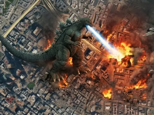
Google thought it had an AI breakthrough. Experts saw a misinformation nightmare Photograph: (AI-Generated/X)
Google has rolled back a newly launched AI-powered Google Earth feature after researchers and OSINT experts warned it could be used to generate convincing fake satellite imagery. The company said it was removing the "create image" tool while it develops stronger safeguards.
Google has rolled back a newly launched artificial intelligence feature in Google Earth after researchers and open-source intelligence (OSINT) experts warned it could be exploited to generate realistic fake satellite imagery and spread disinformation.
On Friday (Jul 31), Google Earth and Google AI introduced on X the tool, using which they said users can "combine rich satellite and 3D imagery with text prompts to reimagine your favourite place around the globe."
The company confirmed that it was disabling the "create image" tool, which had been introduced just a day earlier. Here's what happened.
What did the Google AI 'create image' feature do?
The feature allowed users to generate AI-created visualisations using Google's Nano Banana 2 image generation model layered over Google Earth's satellite, aerial and 3D mapping data. However, within hours of the company's announcement, the tool was rolled back because alarming AI-generated images started flooding the social media space.
"We've seen geospatial professionals using this feature for a range of useful purposes; however, we've also seen people sharing screenshots of generated imagery that appear to violate our policies," a Google spokesperson said, as quoted by AFP.
"So we're rolling back this feature in Google Earth while we work on implementing stronger guardrails."
Trending Stories
)
)
)
)
)
)
)
)
)
)
)
)
)
)
)
)
)
)
)
)
)
)
)
)
)
)
)
&im=FitAndFill=(700,400))
)
)
)
)
)
)
)
)
&im=FitAndFill=(700,400))
)
)
Google added that users "uniquely trust Google Earth for a reliable view of the world," making it essential to protect that trust.
AI-generated disasters and military targets
According to AFP's testing, the tool was able to generate fabricated satellite images depicting an explosion in Paris, a nuclear facility in Iran, a bomb crater in Russia and an Islamic State training camp in Syria.
It also created fake scenes showing floods in Bangladesh, a migrant caravan camp at the US-Mexico border and a suspicious warehouse in the US state of Georgia.
On X, WION found AI-generated images showing a plane crashing into a towering building, reminiscent of the 9/11 Twin Towers tragedy. Another showed a massive sinkhole right in the middle of Iceland. Others show a decimated aircraft carrier, and one even showed Godzilla destroying a town.
Researchers told AFP that these examples demonstrated how the feature could be misused during conflicts, elections or natural disasters to spread false narratives that appear authentic.
Google's safeguards weren't enough
Before removing the feature, Google said images generated using the tool carried SynthID digital watermarks and pointed to its AI policy prohibiting misinformation and deceptive content. However, critics argued that invisible watermarks alone were insufficient to prevent abuse.
The Centre for Information Resilience described the feature as "irresponsible," warning that public confidence in satellite imagery "has taken decades to build and could be irrevocably damaged overnight."
Volunteer-run verification group GeoConfirmed also urged Google to withdraw the tool, saying it had already observed users experimenting with fake military positions and misleading edits to real-world locations.
Experts sound the alarm
Google had promoted the feature as a way to help users visualise historical events, create real estate plans and generate location-based imagery within seconds. However, digital investigators and satellite imagery analysts warned that the tool blurred the line between authentic satellite images and AI-generated content, potentially making it easier to spread convincing falsehoods.
Digital investigations expert Henk Van Ess criticised the rollout, writing: "Google spent 20 years building the reference the world checks against. Today it added a button that makes things up."
Brady Africk, a satellite imagery analyst at the American Enterprise Institute, said the feature could make it significantly easier to create fabricated satellite images capable of misleading the public. He warned that such content could erode trust in satellite imagery and make verification work far more difficult for journalists, researchers and investigators.
Feature removed after backlash
Following widespread criticism from researchers, journalists and OSINT communities, Google removed the "create image" button from Google Earth while it works on stronger safeguards.
The episode highlights the growing challenge facing technology companies as powerful AI image generators become integrated into platforms that millions of people rely on as trusted sources of real-world information.

