Rain and thunderstorm forecast for some northern Indian states while Kerala awaits monsoon

&imwidth=600&imheight=450&format=webp&quality=medium "Rain and thunderstorm forecast for some northern Indian states while Kerala awaits monsoon")
India monsoon and rain update Photograph: (India Meteorological Department)
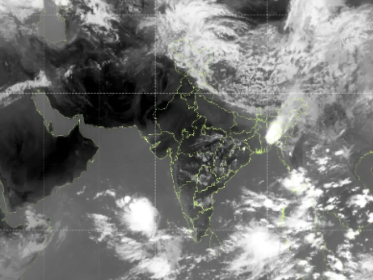
India monsoon and rain update: Rains, thunderstorms and strong winds could hit some Himalayan states in the coming days. The India Meteorological Department released a satellite image showing a massive western disturbance across the upper portions of North India.
Several Himalayan states could witness heavy rainfall as the India Meteorological Department (IMD) has forecast thunderstorms and gusty winds in the region. The latest INSAT-3DS thermal infrared satellite imagery released by the IMD shows a massive western disturbance sweeping across the upper reaches of North India. A huge spiral-shaped cloud mass stretching across Jammu & Kashmir, Himachal Pradesh, and Uttarakhand is clearly visible in the photo. The IMD noted that the western Himalayan region is showing clear signs of an active western disturbance interacting with hot pre-monsoon air over North India, with dense, cold cloud tops hovering above it.
Rainfall and thunderstorms in J&K and Himachal
Intense rainfall, lightning and localised hailstorms are expected in Jammu & Kashmir, and Himachal Pradesh as bright white cloud bands signal the formation of thunderclouds. Besides this , the activity on the map indicates strengthening monsoon activity in the Bay of Bengal and the Arabian Sea. Large clusters of deep convective clouds can be seen building rapidly near Kerala and Lakshadweep. The cloud formations indicate a surge in moisture moving from the equatorial Indian Ocean toward the Kerala coast—one of the most definitive signs that the southwest monsoon is about to make landfall.
The IMD had earlier predicted the onset of monsoon in Kerala for May 26, but the date is expected to shift to May 28. However, it has maintained that it will definitely arrive before June 1, the normal date for the start of the monsoon in India. Satellite images released by the IMD strongly back this prediction, as thick cloud bands are visible southwest of Kerala. Thunderstorm clusters are also forming over the southeast Arabian Sea. The IMD has warned of isolated heavy to very heavy rainfall across parts of Kerala between May 28 and June 3.
Also Read: IMD issues 'orange alert' for Delhi as heatwave sweeps North India; temp likely to touch 46°C
Trending Stories
&imwidth=280&imheight=210&format=webp&quality=medium)
&imwidth=280&imheight=210&format=webp&quality=medium)
&imwidth=280&imheight=210&format=webp&quality=medium)
&imwidth=280&imheight=210&format=webp&quality=medium)
&imwidth=280&imheight=210&format=webp&quality=medium)
&imwidth=280&imheight=210&format=webp&quality=medium)
&imwidth=280&imheight=210&format=webp&quality=medium)
&imwidth=280&imheight=210&format=webp&quality=medium)
&imwidth=280&imheight=210&format=webp&quality=medium)
&imwidth=280&imheight=210&format=webp&quality=medium)
&imwidth=280&imheight=210&format=webp&quality=medium)
&imwidth=280&imheight=210&format=webp&quality=medium)
&imwidth=280&imheight=210&format=webp&quality=medium)
&imwidth=280&imheight=210&format=webp&quality=medium)
&imwidth=280&imheight=210&format=webp&quality=medium)
&imwidth=280&imheight=210&format=webp&quality=medium)
&imwidth=280&imheight=210&format=webp&quality=medium)
&imwidth=280&imheight=210&format=webp&quality=medium)
&imwidth=280&imheight=210&format=webp&quality=medium)
&im=FitAndFill=(700,400)&imwidth=280&imheight=210&format=webp&quality=medium)
&imwidth=280&imheight=210&format=webp&quality=medium)
&imwidth=280&imheight=210&format=webp&quality=medium)
&imwidth=280&imheight=210&format=webp&quality=medium)
&imwidth=280&imheight=210&format=webp&quality=medium)
&imwidth=280&imheight=210&format=webp&quality=medium)
&imwidth=280&imheight=210&format=webp&quality=medium)
&im=FitAndFill=(700,400)&imwidth=280&imheight=210&format=webp&quality=medium)
&imwidth=280&imheight=210&format=webp&quality=medium)
&imwidth=280&imheight=210&format=webp&quality=medium)
&imwidth=280&imheight=210&format=webp&quality=medium)
&imwidth=280&imheight=210&format=webp&quality=medium)
&im=FitAndFill=(700,400)&imwidth=280&imheight=210&format=webp&quality=medium)
&imwidth=280&imheight=210&format=webp&quality=medium)
&imwidth=280&imheight=210&format=webp&quality=medium)
Heatwave in Delhi
Meanwhile, much or northern and central India continue to reel under an intense heatwave. On May 24, the highest maximum temperature stood at 47.2 degrees Celsius in Brahmpuri (Vidarbha). On the same night (intervening night of 24 and 25), Delhi once again recorded its highest nighttime temperature in 14 years at 32.4 degrees Celsius. Just last week, the capital seared at 31.9 degrees Celsius. The last time Delhi witnessed such a high temperature at night was on May 26, 2012.

