‘El Nino is being supersized’: UN warns of record heat and extreme weather

&imwidth=600&imheight=450&format=webp&quality=medium "‘El Nino is being supersized’: UN warns of record heat and extreme weather")
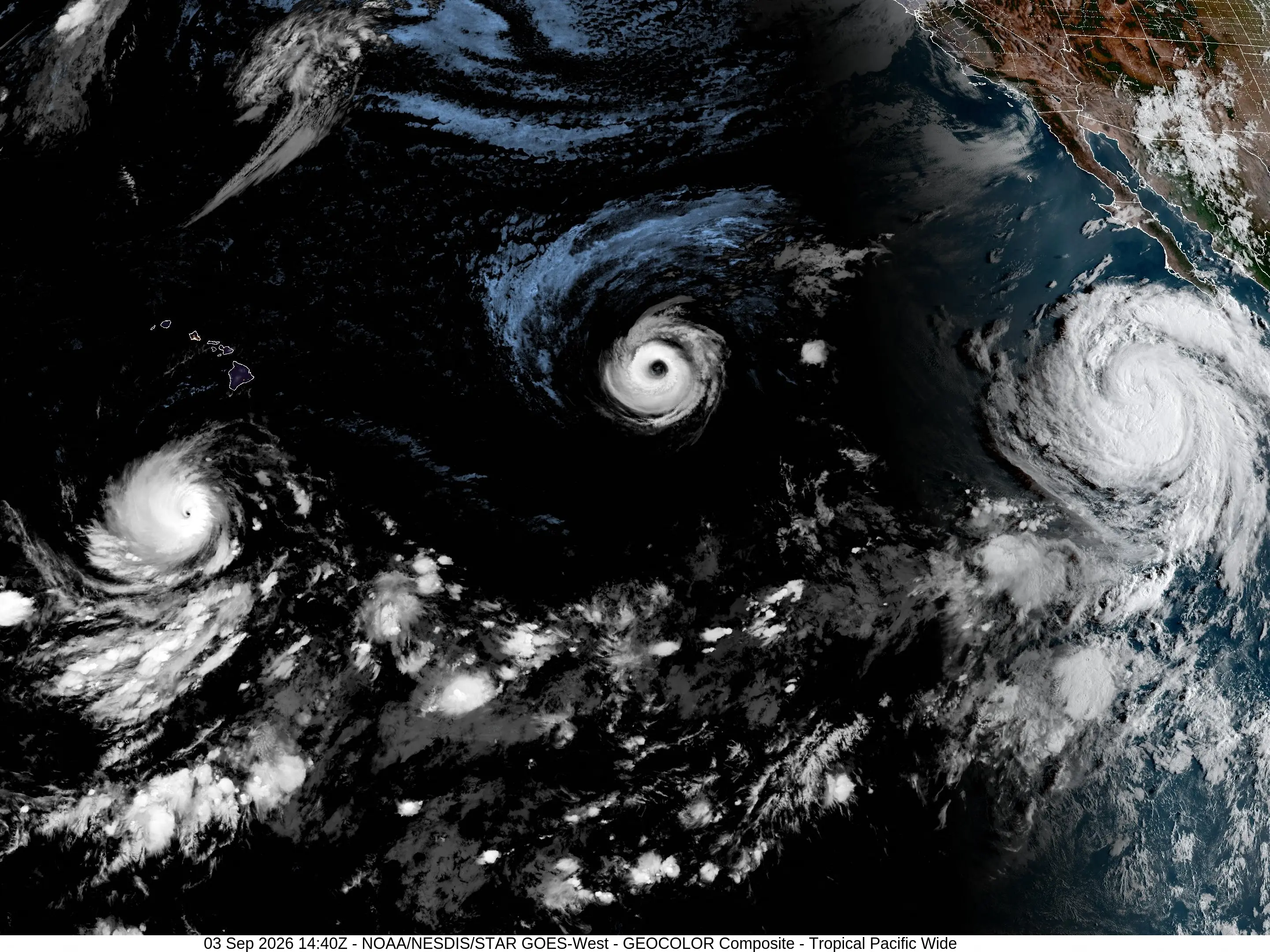
A rare trio of hurricanes were churning through the Pacific Ocean on September 3, 2026, which scientists attributed to waters warmed by a historically strong El Nino phenomenon. Photograph: (AFP)
A “supersized” El Nino could become the strongest in 40 years, WMO warns, threatening record heat, floods and droughts worldwide as global temperatures rise.
A powerful El Nino is building across the Pacific and could become the strongest recorded since modern monitoring began four decades ago, the World Meteorological Organization warned Thursday (Sep 3). The UN weather agency said the naturally occurring phenomenon is expected to intensify to “very strong” levels in the coming months and is almost certain to continue through February.
“If this trajectory continues, it may be stronger than anything since our monitoring began – so literally off the charts we have used for the past four decades,” WMO chief Celeste Saulo told reporters in Geneva.
El Nino heats surface waters across the central and eastern equatorial Pacific, disrupting rainfall, winds and temperatures far beyond the region. Its peak is expected toward the end of the year, but its influence could continue into 2027.
Heat and extreme weather
The warning comes as global temperatures are already at exceptional levels. The powerful 2023-24 El Nino helped make 2024 the hottest year on record, and Saulo said “we should not be surprised if this record is broken”.
UN Secretary-General Antonio Guterres described the developing event in stark terms.
Trending Stories
&imwidth=280&imheight=210&format=webp&quality=medium)
&imwidth=280&imheight=210&format=webp&quality=medium)
&imwidth=280&imheight=210&format=webp&quality=medium)
&imwidth=280&imheight=210&format=webp&quality=medium)
&imwidth=280&imheight=210&format=webp&quality=medium)
&imwidth=280&imheight=210&format=webp&quality=medium)
&imwidth=280&imheight=210&format=webp&quality=medium)
&imwidth=280&imheight=210&format=webp&quality=medium)
&imwidth=280&imheight=210&format=webp&quality=medium)
&imwidth=280&imheight=210&format=webp&quality=medium)
&imwidth=280&imheight=210&format=webp&quality=medium)
&imwidth=280&imheight=210&format=webp&quality=medium)
&imwidth=280&imheight=210&format=webp&quality=medium)
&imwidth=280&imheight=210&format=webp&quality=medium)
&imwidth=280&imheight=210&format=webp&quality=medium)
&imwidth=280&imheight=210&format=webp&quality=medium)
&imwidth=280&imheight=210&format=webp&quality=medium)
&imwidth=280&imheight=210&format=webp&quality=medium)
&imwidth=280&imheight=210&format=webp&quality=medium)
&im=FitAndFill=(700,400)&imwidth=280&imheight=210&format=webp&quality=medium)
&imwidth=280&imheight=210&format=webp&quality=medium)
&imwidth=280&imheight=210&format=webp&quality=medium)
&imwidth=280&imheight=210&format=webp&quality=medium)
&imwidth=280&imheight=210&format=webp&quality=medium)
&imwidth=280&imheight=210&format=webp&quality=medium)
&imwidth=280&imheight=210&format=webp&quality=medium)
&im=FitAndFill=(700,400)&imwidth=280&imheight=210&format=webp&quality=medium)
&imwidth=280&imheight=210&format=webp&quality=medium)
&imwidth=280&imheight=210&format=webp&quality=medium)
&imwidth=280&imheight=210&format=webp&quality=medium)
&imwidth=280&imheight=210&format=webp&quality=medium)
&im=FitAndFill=(700,400)&imwidth=280&imheight=210&format=webp&quality=medium)
&imwidth=280&imheight=210&format=webp&quality=medium)
&imwidth=280&imheight=210&format=webp&quality=medium)
“El Nino is being supersized before our eyes,” he said. “The science leaves no room for doubt: the planet is in uncharted waters, and those waters are heating up.”
The WMO warned of heightened risks of floods, drought and extreme heat, with agriculture, water, energy and health systems particularly exposed.
“This exceptional El Nino... has the potential to deliver a massive blow to communities and economies across the world”, Saulo said.
“We are already seeing disruption and devastation from droughts and floods, and we expect these impacts to increase as El Nino intensifies,” he added.
Pacific waters surge
Ocean temperatures are providing a clear signal of the strengthening event. Sea surface temperatures in the central-eastern equatorial Pacific were about 1.5C above average between May and July, while weekly readings later climbed as high as 2.6C above normal.
In some areas, temperatures beneath the surface were more than 8C above average during July and early August.
El Nino itself is not caused by climate change. But scientists expect the warming phenomenon to add heat to an already hotter planet, increasing pressure on communities facing more extreme weather.

