‘Extraordinary circumstances’: Planet Labs halts Iran conflict imagery indefinitely after US request

&imwidth=600&imheight=450&format=webp&quality=medium "‘Extraordinary circumstances’: Planet Labs halts Iran conflict imagery indefinitely after US request")
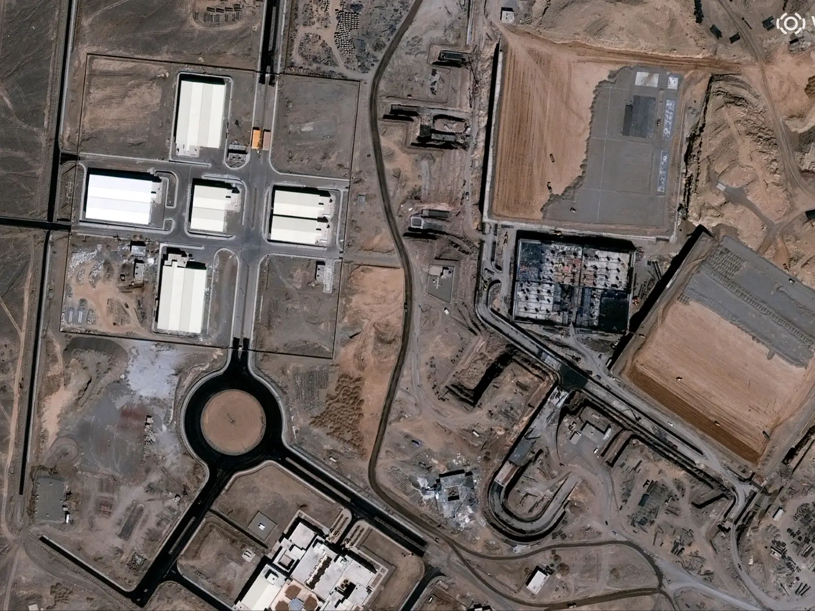
This handout satellite image courtesy of Vantor taken on September 16, 2002 and released on March 2, 2026 shows a view of the Natanz nuclear complex facility under construction with the vehicle ramp and personnel entrances visible near Natanz, Isfahan province, Iran. Photograph: (AFP)
At the request of the US government, satellite firm Planet Labs will indefinitely restrict high-resolution imagery of Iran and West Asian conflict zones to prevent adversaries from targeting allied facilities.
Satellite imaging company Planet Labs has announced it will indefinitely withhold imagery of Iran and the wider conflict zone in West Asia, after a request from the US government, according to a report by Reuters. The California-based firm said in an email to customers on Saturday (April 4) that Washington had requested that all satellite imagery providers restrict visuals of the ongoing conflict region indefinitely.
The move marks a significant escalation from a previous 14-day delay imposed last month on the release of such images.
Planet Labs said the restrictions are intended to prevent adversaries from using high-resolution satellite imagery to identify and target facilities linked to the US and its allies. The company added that the policy is expected to remain in place until the conflict comes to an end. However, the firm noted that exceptions may be made on a case-by-case basis, particularly for urgent, mission-critical needs or where there is a clear public interest.
“These are extraordinary circumstances, and we are doing all we can to balance the needs of all our stakeholders,” the company said, as quoted by Reuters. Planet Labs operates one of the world’s largest fleets of Earth-imaging satellites, supplying frequently updated visuals to governments, media organisations and private clients.
The ongoing conflict in West Asia began on February 28 after joint US-Israeli strikes on Iran. Since then, the war has resulted in thousands of casualties and has contributed to a deepening global energy crisis, underscoring the strategic sensitivity of real-time satellite intelligence in modern warfare.
Trending Stories
&imwidth=280&imheight=210&format=webp&quality=medium)
&imwidth=280&imheight=210&format=webp&quality=medium)
&imwidth=280&imheight=210&format=webp&quality=medium)
&imwidth=280&imheight=210&format=webp&quality=medium)
&imwidth=280&imheight=210&format=webp&quality=medium)
&imwidth=280&imheight=210&format=webp&quality=medium)
&imwidth=280&imheight=210&format=webp&quality=medium)
&imwidth=280&imheight=210&format=webp&quality=medium)
&imwidth=280&imheight=210&format=webp&quality=medium)
&imwidth=280&imheight=210&format=webp&quality=medium)
&imwidth=280&imheight=210&format=webp&quality=medium)
&imwidth=280&imheight=210&format=webp&quality=medium)

&imwidth=280&imheight=210&format=webp&quality=medium)
&imwidth=280&imheight=210&format=webp&quality=medium)
&imwidth=280&imheight=210&format=webp&quality=medium)
&imwidth=280&imheight=210&format=webp&quality=medium)
&imwidth=280&imheight=210&format=webp&quality=medium)
&imwidth=280&imheight=210&format=webp&quality=medium)
&im=FitAndFill=(700,400)&imwidth=280&imheight=210&format=webp&quality=medium)
&imwidth=280&imheight=210&format=webp&quality=medium)
&imwidth=280&imheight=210&format=webp&quality=medium)
&imwidth=280&imheight=210&format=webp&quality=medium)
&imwidth=280&imheight=210&format=webp&quality=medium)
&imwidth=280&imheight=210&format=webp&quality=medium)
&imwidth=280&imheight=210&format=webp&quality=medium)
&imwidth=280&imheight=210&format=webp&quality=medium)
&im=FitAndFill=(700,400)&imwidth=280&imheight=210&format=webp&quality=medium)
&imwidth=280&imheight=210&format=webp&quality=medium)
&im=FitAndFill=(700,400)&imwidth=280&imheight=210&format=webp&quality=medium)
&imwidth=280&imheight=210&format=webp&quality=medium)
&imwidth=280&imheight=210&format=webp&quality=medium)
&im=FitAndFill=(700,400)&imwidth=280&imheight=210&format=webp&quality=medium)
&imwidth=280&imheight=210&format=webp&quality=medium)
&imwidth=280&imheight=210&format=webp&quality=medium)
&imwidth=280&imheight=210&format=webp&quality=medium)
Also read: 'This is not our war, we aren't going to be dragged into it': Starmer on US vs NATO amid Iran war

