
&imwidth=800&imheight=600&format=webp&quality=medium "Exclusive: NASA-ISRO satellite to capture 4,300 GB of Earth imagery daily")
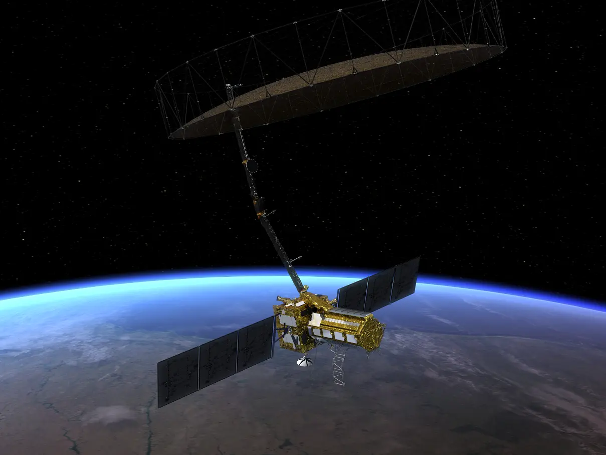
The NASA-ISRO Synthetic Aperture Radar (NISAR) satellite, jointly built by the American and Indian space agencies, will be capturing an unprecedented amount of Earth-imaging data as it circles 747 kms above the Earth’s surface. “NISAR would be capturing 4.37 Terabytes (over 4,300 GB) of data per day,” Dr. Sanghamitra Dutta, NISAR Program Executive, NASA Headquarters, told WION’s Sidharth M.P. For context, an average consumer laptop comes with 512 GB of storage space. Therefore, NISAR would capture enough imagery to fill up at least eight laptops in a single day.
Weighing nearly 2,400 kg, NISAR is meant to carry out high-resolution Earth imaging for at least three years. NISAR would generate a whopping 1569 Terabytes (over 1.5 million GB) of imaging data, considering its minimal operational life of three years. Over this period of three years, NISAR would generate enough data to fill up at least 2,900 laptops. The first-ever satellite to be built jointly by space agencies of India and the US, NISAR is meant to monitor Earth’s vital signs and help understand the impact of climate change and natural disasters, among others.
If everything goes according to plan, the GLSV-F16 rocket carrying the NISAR satellite will lift off from the Indian Spaceport Satish Dhawan Space Centre, Sriharikota, at around 5:40 pm Indian time, on 30th July, Wednesday. ISRO has officially announced the launch date and time for the mission.

24/7 Earth-monitoring for several years
Typically, an Earth-imaging satellite would have to only capture images when passing over its area of interest or region of study. When not flying over the area of interest, the imaging equipment can be turned off and put to rest. That’s where NISAR stands out—its job is to capture earth imaging data round-the-clock over its operational life of more than three years. NASA says NISAR will be capable of mapping the Earth’s land and ice-covered surface twice in a period of twelve days. While NISAR is expected to have a minimum mission life of three years, it is likely to perform its duties for five years or longer. Satellite life depends on how much fuel it carries on board, the design life of its electronic components, and other technical parameters.
NISAR is the first satellite mission to collect radar data in two microwave bandwidth regions, called the L-band and the S-band, to measure changes of our planet’s surface, including movements as small as a centimetre. This allows the mission to observe a wide range of Earth processes, from the flow rates of glaciers and ice sheets to the dynamics of earthquakes and volcanoes. NISAR will map the entire globe in 12 days.
Trending Stories
)
Emmys 2026: Matthew Rhys wins Best Actor twice, sets historic 78-year record
)
3 Italians fly from Delhi to Munich without immigration clearance; Air India gets notice on major security lapse
)
Did India risk its US trade deal despite softer stance at BRICS?
)
Pakistan puts Pak Rs 70 lakh bounty on UN terrorist Masood Azhar; move draws skepticism in Delhi
)
‘US ensuring global energy supplies’: Trump demands reimbursement for securing Strait of Hormuz
)
'She married her brother': Ilhan Omar faces criminal probe over immigration fraud claims
)
'Huge destructive power': North Korea calls its latest missile launches 'live-fire drill' even as US dismisses 'immediate threat'
)
Ukraine strikes Syzran Oil Refinery deep inside Russia, fires erupt
)
‘Let’s go’: Newly declassified videos show dramatic rescue of US Air Force officers downed in Iran
)
Emmy Awards 2026: Widow's Bay and The Pitt win in lead categories- check out the complete list of winners
)
Emmys 2026 In Memoriam: Catherine O’Hara honoured by on-screen children Macaulay Culkin, Annie Murphy, Dan Levy; Dolly Parton, Rob Reiner remembered
)
Iran, India agree to deepen humanitarian and political ties, President Pezeshkian says
)
‘Want to reset ties with India, have engagement based on mutual interests,’ says Bangladesh minister
&im=FitAndFill=(700,400))
Emmys 2026 Red Carpet: Zendaya, Nicole Kidman and Julia Garner lead the glamour peak
)
Turkish Airlines plane flies through a storm three times, triggering severe turbulence
&im=FitAndFill=(700,400))
Why Chinese PL-15 air-to-air missiles use dual-pulse motors compared to European interceptors
)
What is Hyrox, in news for athlete who soiled herself, but kept running and using common equipment?
)
Russia proposes to build 360 kmph Ivolga FG trains in India: What happened on sidelines of BRICS
)
800 million years old - Scientists discover 'fingerprints' of supercontinent Gondwana in ancient rocks
)
Former Pak PM Imran Khan's ex-wife Jemima Goldsmith marries Australian financier: Who is Cameron O'Reilly
)
Plane carrying prominent figure crashes at Libya’s Misrata airport: Report
)
UPI payments up to Rs 2,000 to stays free, but bigger transactions may soon cost you: Govt
&im=FitAndFill=(700,400))
New OTT releases this week (September 14-20, 2026): Lust Stories 3, Waiting Hai, Irumudi- 5 new titles coming on Netflix, Prime Video and more
)
Sent home midway from UK tour, Pakistan's Salman Agha hits 300* in domestic return
)
Who is Kalyan Bainsla, accused in the Gurugram hit-and-run case involving woman biker?
)
Nigerian Navy seizes 10,000 litres of suspected illegal fuel in Rivers State crackdown
)
Saudi Arabia discovers 110 million tonnes of Uranium-rich ore in Madinah region
)
Dodgers beat Reds for playoff berth in bid for third consecutive World Series
)
Ecstasy tablets are rage in 'drug haven' Libya | Gravitas
)
'Now Trump is copying us': Shivakumar links US $5,000 plan to Congress guarantees
)
Video of Pakistani lawmaker struggling to read English tribute to Jinnah goes viral - WATCH
)
Trump downplays China's alleged 'help' to Iran in strike on Jordan base | Gravitas
)
Trump loses Supreme Court battle over mail ballots ahead of US midterms: What happened?
)
BCCI VP Rajeev Shukla says Mohsin Naqvi 'did not object' India refusing trophy from ACC chief
)
Photographs, LeT labels vanish from two 2008 Mumbai attack entries in Pakistan’s most wanted list
)
Delhi govt to roll out ₹13,820 crore development projects under Seva Sankalp Abhiyan: CM Rekha Gupta
)
UK man admits drugging, raping wife for 20 years in shocking abuse case
)
Extreme warming in Indian Ocean added 695 billion tons of ice to Antarctica ice sheet
)
China thinned Himalayan troop presence in 2025, India defence report says; terms border situation 'stable'
How scientists would manage such vast amount of data from NISAR
Given how NISAR would generate over 4,300 GB of data daily, scientists face a major challenge in managing this vast trove of Earth-imaging information. Like all our gadgets, the Solid State Data recorder on the NISAR satellite has a limited capacity, which is why NASA and ISRO are working on quick methods to downlink the data (send the data from the satellite to Earth) as frequently as possible. Think of it like rapidly downloading all photos and videos from a camera’s memory card before deleting them to free up space for the next use.
NASA’s Dr. Dutta says that NISAR could generate the highest-ever amount of data from a single-satellite mission. “There has never been so much data coming from a mission on a daily basis, and we have prepared the downlink stations (Earth-based stations that receive data from satellites) for such high data rates. This would also help NASA in getting ready for future missions, when there would be a much higher volume of data transfers.” Notably, all of NISAR’s data would be archived and shared with the science community.
How a radar-imaging satellite works
Conventional Earth-imaging satellites click detailed colour photos of Earth, very similar to what a high-end camera does. In comparison, a radar-imaging satellite works in a totally different manner. Instead of giving an optics-based picture (like a photograph), radar satellites constantly beam radar waves onto the Earth. The features on Earth’s surface (buildings, trees, mountains, water bodies, roads, and glaciers) reflect these radar waves back to the satellite. By collecting and processing the reflected radar waves, radar-imaging satellites deliver imagery during day and night, during all weather conditions.
Typically, conventional satellites’ ability to deliver images is obstructed by clouds and weather-related phenomena. While conventional optical satellite images are in colour, radar satellite images are inherently black-and-white. However, these black-and-white radar satellite images can be processed to deliver false-colour images for analysis.
Is NISAR a spy satellite?
Synthetic Aperture Radar technology is widely used for military and strategic purposes, as it can delivery imagery during day and night conditions, even amid weather conditions that hinder traditional camera-based satellite imaging. During his time at the helm of ISRO, when asked if NISAR was a spy satellite, Dr. S. Somanath categorically stated, “NISAR is not a spy satellite.” He elaborated that the data generated by NISAR would be shared in a free and open manner with the entire scientific community. He said that it was purely a science mission and aimed at studying the Earth in high detail, which would help draw better conclusions on various phenomena that are affecting our planet.
Dr. Datta from NASA highlighted that the first civilian SAR satellite in history, called SEASAT, was launched by NASA in 1978. SEASAT led to a series of NASA space shuttle-based radar missions and inspired the development of spaceborne SAR systems worldwide. She added that Japan and Europe also have SAR satellites for Earth-imaging purposes.
All NISAR science data, L-band and S-band, will be freely available and open to the public, consistent with the long-standing NASA Earth Science open data policy. NASA has chosen the Alaska Satellite Facility Distributed Active Archive Center (DAAC) to host the mission’s data and products, said the American space agency.
