2/3rd of glacier detached, collapsed: ISRO satellite images reveal what triggered Nepal floods

&imwidth=600&imheight=450&format=webp&quality=medium "2/3rd of glacier detached, collapsed: ISRO satellite images reveal what triggered Nepal floods")
ISRO satellite images reveal what triggered Nepal floods
ISRO’s preliminary satellite analysis has revealed that nearly two-thirds of a glacier detached and collapsed during deadly flash floods in Tibet and Nepal. The massive ice and debris flow caused rapid melting, severely affecting Rasuwa, Rasuwagadhi, Timure and the Trishuli River
In its satellite imagery-based preliminary analysis of the deadly flash floods that struck Tibet and Nepal on Wednesday(26th August), Indian Space agency ISRO has revealed that almost two-third of the glacier's body detached and collapsed. This massive collapse led to large debris and ice mass flow downslope and downstream, further causing rapid melting and inundation. The analysis carried out by ISRO's National Remote Sensing Centre(NRSC) points out that the worst affected areas are Rasuwa, Rasuwagadhi, Timure, and Trishuli River. ISRO reiterated that this is a preliminary analysis and that a detailed assessment will be carried out.
ISRO's Hyderabad-based NRSC is responsible for establishing ground stations that receive satellite data, generating data products, dissemination to users, and development of remote sensing applications including disaster management support, geospatial services for governance, and capacity building.
How satellite images were compared and analysed
NRSC's Disaster Management Support Group carried out the preliminary analysis based on comparison of images captured by multiple satellites including ISRO's Resourcesat-2A, NASA's LANDSAT-9 and European Space Agency's SENTINEL-2.
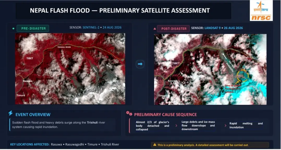
By juxtaposing SENTINEL-2 satellite imagery from 24thAugust(two days prior to disaster) and 26thAugust(post-disaster), ISRO's analysis pin points the zone of glacier breakage and collapse, the Ice-rock avalanche. The overall disaster event is described as a 'sudden flash flood and heavy debris surge along the Trishuli river system causing rapid inundation'.
Trending Stories
&imwidth=280&imheight=210&format=webp&quality=medium)
&imwidth=280&imheight=210&format=webp&quality=medium)
&imwidth=280&imheight=210&format=webp&quality=medium)
&imwidth=280&imheight=210&format=webp&quality=medium)
&imwidth=280&imheight=210&format=webp&quality=medium)
&imwidth=280&imheight=210&format=webp&quality=medium)
&imwidth=280&imheight=210&format=webp&quality=medium)
&imwidth=280&imheight=210&format=webp&quality=medium)
&imwidth=280&imheight=210&format=webp&quality=medium)
&imwidth=280&imheight=210&format=webp&quality=medium)
&imwidth=280&imheight=210&format=webp&quality=medium)
&imwidth=280&imheight=210&format=webp&quality=medium)
&imwidth=280&imheight=210&format=webp&quality=medium)
&imwidth=280&imheight=210&format=webp&quality=medium)
&imwidth=280&imheight=210&format=webp&quality=medium)
&imwidth=280&imheight=210&format=webp&quality=medium)
&imwidth=280&imheight=210&format=webp&quality=medium)
&imwidth=280&imheight=210&format=webp&quality=medium)
&imwidth=280&imheight=210&format=webp&quality=medium)
&imwidth=280&imheight=210&format=webp&quality=medium)
&imwidth=280&imheight=210&format=webp&quality=medium)
&imwidth=280&imheight=210&format=webp&quality=medium)
&imwidth=280&imheight=210&format=webp&quality=medium)
&im=FitAndFill=(700,400)&imwidth=280&imheight=210&format=webp&quality=medium)
&imwidth=280&imheight=210&format=webp&quality=medium)
&imwidth=280&imheight=210&format=webp&quality=medium)
&im=FitAndFill=(700,400)&imwidth=280&imheight=210&format=webp&quality=medium)
&imwidth=280&imheight=210&format=webp&quality=medium)
&imwidth=280&imheight=210&format=webp&quality=medium)
&imwidth=280&imheight=210&format=webp&quality=medium)
&imwidth=280&imheight=210&format=webp&quality=medium)
&imwidth=280&imheight=210&format=webp&quality=medium)
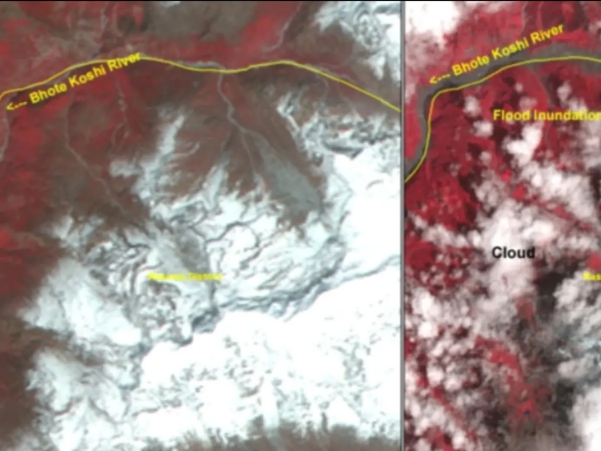
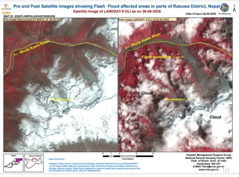
Further, ISRO juxtaposes imagery captured by its Resourcesat-2A satellite on 4thApril 2026(four months prior to disaster) and imagery captured by LANDSAT-9 on 26thAugust(post-disaster). Comparing the two, the analysis depicts the massively swelled up Bhote Koshi river and the resultant flood inundation in the Rasuwa district of Nepal.
The disaster that unfolded in Tibet and Nepal
The massive flash floods originating in Tibet swept through Central Nepal on Wednesday, devastating several towns and villages, washing away bridges and buildings, damaging several hydropower projects and crippling power generation capacity. Estimates say that over 160 lives have been lost and over a thousand people are missing across Tibet and Nepal.
The United States Geological Survey(USGS) states that this event was initially reported as a magnitude 4.4 earthquake. However, additional analysis of long period seismic waves indicate that the seismic energy was instead generated by a glacial collapse and debris flow.
"A magnitude 5.2 seismic event occurred near the border between Nepal and China on Aug 26 at 8:37 AM local time (10:52 AM China Standard Time). The USGS determined that the seismic event was a glacial collapse and debris flow that caused subsequent catastrophic impacts downstream. This event was initially reported as a magnitude 4.4 earthquake. Additional analysis of nearby seismic stations, long period seismic waves, and satellite imagery led to the determination that the seismic event was instead a glacial collapse and debris flow, and that no earthquake had occurred," said the USGS.
