

&imwidth=800&imheight=600&format=webp&quality=medium "ISRO to setup space tracking radar in Northeast, telescope in Ladakh")
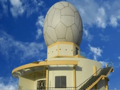
Indian Space agency ISRO is working on setting up facilities across the country to track space objects in Low Earth orbit (about 500-1000kms above the Earth) and potentially, even higher. This comes at a time when Low Earth Orbit is getting congested with satellites and space debris, and the risk of accidental collision is growing rapidly. "The establishment of an optical telescope at Hanle, Ladakh, is underway. Design and review of an indigenous phased array space object tracking radar was completed by a national-level expert committee in 2025. Efforts to establish an indigenously developed radar in the north-eastern part of India are underway. The Baker Nunn Schmidt Telescope (BNST), currently being refurbished at Nainital, under collaboration with ARIES, is also expected to enhance space object tracking capability in the near future," ISRO stated in the Indian Space Situational Awareness Report (ISSAR) for 2025.
At present, ISRO's Multi-Object Tracking Radar (MOTR) at the Satish Dhawan Space Centre in Sriharikota tracks space objects, including Indian rocket bodies and satellites. Multi Object Tracking Radar (MOTR) is an L-Band Active Phased Array Radar designed to track multiple objects. It is a long range tracking radar capable of tracking objects with a radar cross section of 0.25square meters, up to a range of 1000km.
By using radio waves and their reflections to estimate the position of objects, radars operate in both day and night conditions. Inaddition to radars, ISRO is also planning to install optical telescopes, which are only capable of night-time operations in regions with a clear, unobstructed view of the dark sky. This is why a high-altitude cold desert region such as Ladakh has been chosen for installation of telescope. These telescopes are meant to detect space objects(satellites) using sunlight that is reflected off them. A combination of radars and optical telescopes installed at various locations is essential for Space Situational Awareness(SSA), which is the is the process of tracking, monitoring, and predicting the positions of satellites and space debris in Earth’s orbit. This information helps ensure safe, sustainable space operations. It involves gathering data via ground-based sensors and telescopes to avoid collisions and assess risks to space assets.
Just like a person on the ground can see an overflying aircraft only for a minute or two, a tracking facility(radar or antenna) can see a satellite or debris only when it is within its range. Therefore, multiple tracking stations positioned at vantage locations across the globe are required to have near-complete coverage of objects in Earth's orbit.
Trending Stories
&imwidth=180&imheight=135&format=webp&quality=medium)
'My name has always been Ilhan Omar': Congresswoman hits back at Trump, calls him a 'creep'
&imwidth=180&imheight=135&format=webp&quality=medium)
Gravitas | US attack could trigger WW III: Russian planes in Tehran, Israeli jets, US warships in action
&imwidth=180&imheight=135&format=webp&quality=medium)
Viral video shows cross falling on Colombia priest, no official confirmation | WATCH
&imwidth=180&imheight=135&format=webp&quality=medium)
US Navy, Marine Corps boards defy Trump's transgender military ban, vote to retain troops
&imwidth=180&imheight=135&format=webp&quality=medium)
Will the US attack Iran this weekend? Trump's envoy says, 'absolutely'
&imwidth=180&imheight=135&format=webp&quality=medium)
Fauzi teaser out: Prabhas takes on the British Empire in patriotic avatar | Watch
&imwidth=180&imheight=135&format=webp&quality=medium)
India-China face-off continues near Arunachal’s Taksing, reveals ITBP chief in first official confirmation of tensions
&imwidth=180&imheight=135&format=webp&quality=medium)
Nairobi building collapse: Several feared trapped after 16-storey structure crumbles; rescue operation underway
&imwidth=180&imheight=135&format=webp&quality=medium)
Pakistan airline PIA unveils new crew uniforms, faces online criticism
&imwidth=180&imheight=135&format=webp&quality=medium)
Did Neha Bora call for Bangladesh-like GenZ protest, 'anarchy' in India? WION Fact-checks viral claim
&imwidth=180&imheight=135&format=webp&quality=medium)
Scientists make digital nose that can sniff and send scents over the internet
&imwidth=180&imheight=135&format=webp&quality=medium)
'Already tired of his 9-to-5': Baby born with a moustache becomes internet sensation, video goes viral | Watch
&imwidth=180&imheight=135&format=webp&quality=medium)
Horrific video shows the moment 18-year-old fell to her death from Mexico amusement park ride
&imwidth=180&imheight=135&format=webp&quality=medium)
'Black triangle' UFO flying at 1,800mph spotted over sensitive US site: Latest Trump admin UFO file dump
&imwidth=180&imheight=135&format=webp&quality=medium)
IND-W vs ZIM-W, 1st ODI: Rawal, Charani star in India’s nine-wicket win over Zimbabwe
&imwidth=180&imheight=135&format=webp&quality=medium)
Massive 7.2 magnitude quake off Vanuatu triggers tsunami warning for coasts within 300 km
&imwidth=180&imheight=135&format=webp&quality=medium)
Microsoft AI diagnoses complex medical cases more than twice as accurately as doctors, study finds
&imwidth=180&imheight=135&format=webp&quality=medium)
Google Fitbit Air’s new health guardian feature tracks trends: How it works
&imwidth=180&imheight=135&format=webp&quality=medium)
US midterms 2026: Trump revises Canada tariffs as Susan Collins faces tight re-election race in Maine
&imwidth=180&imheight=135&format=webp&quality=medium)
US midterms 2026: Viral video claims Lindsey Graham paid underage men for sex; clip released weeks before his sister's Senate race
&imwidth=180&imheight=135&format=webp&quality=medium)
IND vs NZ 2nd T20I: Shreyas Iyer on brink of breaking Rohit Sharma’s record
&imwidth=180&imheight=135&format=webp&quality=medium)
AI deepfakes are spreading online: Why is removing them so difficult?
&imwidth=180&imheight=135&format=webp&quality=medium)
China's dancing robot turns violent bodyguard, lifts cars and fights intruders - Watch
&imwidth=180&imheight=135&format=webp&quality=medium)
Global cybersecurity alert: PHP flaws trigger website shutdowns as hack attempts surge into millions
&imwidth=180&imheight=135&format=webp&quality=medium)
'You’re a horrible little reporter, aren’t you?': Trump snaps at NBC reporter questioning his support for Ramaswamy's campaign ad
&imwidth=180&imheight=135&format=webp&quality=medium)
Chemical warehouse explosion in Mexico: Several injured in multiple blasts, 1,000 evacuated in León
&imwidth=180&imheight=135&format=webp&quality=medium)
US charges two former FBI officials with lying to Congress about Hunter Biden probes. 'Politically motivated' Trump grievance or something else?
&im=FitAndFill=(700,400)&imwidth=180&imheight=135&format=webp&quality=medium)
New Friday OTT releases (October 23, 2026): Gajab Raat, Dorothy, Chaar Yaar- Watch these 6 new movies and TV shows on Netflix, Prime Video and more
&imwidth=180&imheight=135&format=webp&quality=medium)
Anthropic security chief issues grim cyberattack warning: ‘It’s going to get a lot worse’
&imwidth=180&imheight=135&format=webp&quality=medium)
Tu Hai Meri Kiran film review: Sonakshi Sinha and Zaheer Iqbal's thriller gets tangled in its own twists
&imwidth=180&imheight=135&format=webp&quality=medium)
First Lady Melania Trump secures ceasefire between Russia, Ukraine in Oleshky: White House
&imwidth=180&imheight=135&format=webp&quality=medium)
Jenna Ortega plans TV break after Wednesday: ‘I want to leave time for new things’
&imwidth=180&imheight=135&format=webp&quality=medium)
Emmanuel Macron calls Paris suburb shooting a 'racist terrorist attack' after one killed, several injured
The ever-increasing threat of collisions between space objects
The Government-run Indian space agency ISRO has a total of 53 operational satellites circling the Earth. This includes 22 satellites in Low Earth Orbit (about 500-1000kms above the earth) and 31 satellites in Geosynchronous Earth Orbit(about 36,000kms above the Earth.
ISRO'sIndian Space Situational Awareness Report (ISSAR) for 2025 mentions that there is a growing congestion in Low Earth Orbit, owing to the exponential growth in the number of satellites being placed there and the mounting threat of space debris. The report mentions that the Combined Space Operations Center (CSpOC) of America's USSPACECOM had issued 1,50,000 close approach alerts, which warn operators when satellites and debris pass within a dangerously close distance.
Space debris and satellites in Low earth orbit travel at speeds of 28,000kmph, which means even the smallest pieces of debris colliding with a large object can generate more debris. Based on these alerts, ISRO performed a total of 18 collision-avoidance manoeuvres: 4 for satellites in Geosynchronous Earth Orbit, and 14 for satellites in Low Earth Orbit. The $1.2bn NASA-ISRO Synthetic Aperture Radar(NISAR) satellite was also among those that had to perform a collision avoidance manoeuvre, ISRO said.
As the name suggests, a collision avoidance manoeuvre is a planned trajectory adjustment, where the satellite fires its thrusters to adjust its orbit. Such manoeuvres are done when the probability of collision with debris or another satellite exceeds a safe threshold.
