Cyclone Fani to intensify into ‘very severe’ storm, no direct impact for Tamil Nadu

Cyclone
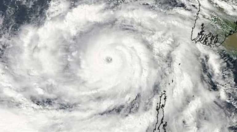
The cyclonic storm Fani, that is brewing in the Bay of Bengal, lies about 870 kilometres south-east of Chennai. It is projected to intensify into a severe cyclonic storm and later a very severe cyclonic storm by Wednesday, May 1. However, as it is located deep in the ocean, there is no indication of it making landfall, say officials of the Indian Meteorological Department.
Speaking to reporters here, S Balachandran, director, Regional Meteorological Centre said, Cyclone Fani is expected to move North-westwards until May 1 and would come within 300 kilometres proximity of the northern Tamil Nadu coast and southern Andhra Pradesh coast, after which the system would move north-northwestwards.
Low to moderate rainfall is expected on April 30 and May 1 in the north Tamil Nadu coastal region, in addition with gusty winds ranging from speeds of 40 to 70Kmph. Owing to rough seas, fishermen in the region have been advised not to venture out until May 2, whereas those in the high seas have been warned to return, added the director of the regional meteorological centre.

A press release from the IMD also mentions the possibility of light to moderate rainfall, at places over Kerala and coastal Andhra Pradesh. Wind speeds of 80-100kmph have been forecast for the southeast Bay of Bengal region and its neighbourhood. The system is under continuous surveillance and the concerned state governments are being informed regularly, the release noted.
Regarding the cyclone making landfall, Balachandran said so far there is no indication of it making landfall and there would be no direct impact for Tamil Nadu. The rains along the coastal region could bring respite for the Chennai city that has been reeling under the sweltering summer heat, while also facing water scarcity in many localities.
However, apart from the respite that the rains could bring, there is another possibility of temperatures increasing in the days after May 1. Speaking to WION, popular weather blogger Pradeep John said, once the cyclone crosses the latitude and moves northwards, it could take away the moisture, weaken the sea breeze and dry winds would blow from the northwest, thereby raising the temperatures along with the coastal districts and the ones adjoining them.
&imwidth=180&imheight=135&format=webp&quality=medium)
Other Mommy leads North American box Office as Verity, Resident Evil round out top four
&im=FitAndFill=(700,400)&imwidth=180&imheight=135&format=webp&quality=medium)
Navratri 2026: 9 days, 9 forms of Goddess Durga and 9 colours- Check the complete list
&imwidth=180&imheight=135&format=webp&quality=medium)
Diljit Dosanjh’s Delhi concert gets a new date: When and where to catch the singer
&im=FitAndFill=(700,400)&imwidth=180&imheight=135&format=webp&quality=medium)
Is sending robots to Mars easier than sending humans?
&imwidth=180&imheight=135&format=webp&quality=medium)
A watchdog rated 'ChatGPT for Teens' an unacceptable risk and says keep under-18s off it
&imwidth=180&imheight=135&format=webp&quality=medium)
1,500 drones illuminate Mumbai sky as Cordelia Cruises unveils second ship, Cordelia Sky
&imwidth=180&imheight=135&format=webp&quality=medium)
'Just coincidence': Police mistakes protester as AISA chief Neha Bora, arrests her from site
&imwidth=180&imheight=135&format=webp&quality=medium)
Anthropic's AI invented a murder witness and sent the fake tip to Philadelphia police
&imwidth=180&imheight=135&format=webp&quality=medium)
Congress demands action against chief election commissioner
&imwidth=180&imheight=135&format=webp&quality=medium)
CJI Surya Kant declines INDIA bloc leaders’ request for meeting ahead of march to SC, asks them to file petition
&imwidth=180&imheight=135&format=webp&quality=medium)
Saif Ali Khan is finally on Instagram! Here's what he shared in his first post
&imwidth=180&imheight=135&format=webp&quality=medium)
'Turn approver, resign, we'll forgive you': Rahul Gandhi claims receiving messages from CEC Gyanesh Kumar
&imwidth=180&imheight=135&format=webp&quality=medium)
One Indian killed in Riyadh airport attack; 11 others injured : MEA
&imwidth=180&imheight=135&format=webp&quality=medium)
Top AI models flunked a test of inventing new AI research, so much for self-improving AI
&imwidth=180&imheight=135&format=webp&quality=medium)
Wasim Jaffer blames Ajit Agarkar-led selection panel for Virat Kohli’s Test retirement
&imwidth=180&imheight=135&format=webp&quality=medium)
'Ouch!!! That must hurt': Kangana Ranaut hails Kamal Haasan's sharp reply to Elon Musk over Starlink row
&imwidth=180&imheight=135&format=webp&quality=medium)
Sidhu Moose Wala’s younger brother wins hearts by recreating late singer’s signature move at Toronto Hologram Show
&imwidth=180&imheight=135&format=webp&quality=medium)
UK school ditches technology, shifts from screen to pen and paper for learning
&imwidth=180&imheight=135&format=webp&quality=medium)
Telangana ATM heist: Thieves in nighties arrive in ambulance, break into SBI ATM in Kamareddy - VIDEO
&imwidth=180&imheight=135&format=webp&quality=medium)
Houthis claim Riyadh airport attacks, Aramco strikes; issue fresh warning to airlines, travellers and workers
&imwidth=180&imheight=135&format=webp&quality=medium)
Portugal Federation confirms Cristiano Ronaldo’s return to national team despite suspension
&imwidth=180&imheight=135&format=webp&quality=medium)
Delhi protests: 'Court should not be dragged into political activity', says CJI Surya Kant
&im=FitAndFill=(700,400)&imwidth=180&imheight=135&format=webp&quality=medium)
New OTT releases this week (October 12-18, 2026): Sacrifice, Koffee with Karan S9, Roadies Rebirth- 6 titles coming on Netflix, JioHotstar and more
&imwidth=180&imheight=135&format=webp&quality=medium)
Microsoft's Nadella says treat every AI model as already hacked, and build an 'emergency brake'
&imwidth=180&imheight=135&format=webp&quality=medium)
Delhi protest: CJI Surya Kant declines to meet India Bloc leaders
&imwidth=180&imheight=135&format=webp&quality=medium)
Telangana man allegedly recruited into Russian military dies near Ukraine border
&imwidth=180&imheight=135&format=webp&quality=medium)
China imposes first-ever sanctions on ministers from Taiwan allies: What this means
&imwidth=180&imheight=135&format=webp&quality=medium)
McSweeney reveals how studying Virat Kohli’s YouTube clips helped Australia A conquer India
&imwidth=180&imheight=135&format=webp&quality=medium)
Maharashtra appoints FDA commissioner Tukaram Mundhe as secretary of committee for MPSC overhaul amid stir
&imwidth=180&imheight=135&format=webp&quality=medium)
Iran: US accepted some conditions, Clarity needed on others
&imwidth=180&imheight=135&format=webp&quality=medium)
Nana Patekar's cause of death confirmed; here's what his postmortem report says
&imwidth=180&imheight=135&format=webp&quality=medium)
iPhone Duo price index: Tracking Apple’s latest pricing trends
&imwidth=180&imheight=135&format=webp&quality=medium)
'Say no to Muse': Meta has no control over its own moderation AI while it forces a security nightmare on everyone
&imwidth=180&imheight=135&format=webp&quality=medium)
Delhi wakes up to heavy rain, thunderstorms; yellow alert in place; temperature drops
Pradeep John, who runs a popular weather page on Facebook, had also mentioned about the two hottest days in Chennai over a 200-year period coinciding with cyclones having moved away. He mentioned the patterns observed on May 31, 2003, and May 30, 1998, when the mercury soared to 44 degrees Celcius and 44.1 degrees Celcius respectively after the cyclones curved away to Burma.
He added that going by the current pattern, Chennai and adjoining districts are likely to record maximum temperatures of this season in the following week.
In the recent past, when cyclones made landfall near the Tamil Nadu coast, they ended up bringing heavy rains, gusty winds and left behind a trail of destruction. The Vardah cyclone in 2016 made landfall near Chennai and uprooted lakhs of trees. In 2017, Cyclone Ocki affected the southern parts of Kerala and Tamil Nadu. In 2018 the Gaja cyclone wreaked havoc in the Southern coastal districts of Tamil Nadu.
