UN votes to correct world map that visually shrank Africa for 450 years

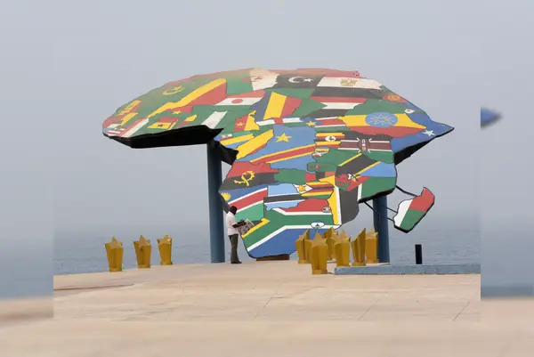
A man reads his newspaper in front a map of Africa at the Place du Souvenir Africain, in Dakar, on January 27, 2016. Photograph: (Credit: AFP)
The UN General Assembly has voted 164–1 to phase out the 1569 Mercator map projection in favour of the Equal Earth map. Learn how the new map accurately reflects Africa's true size after 450 years of distortion.
The United Nations General Assembly voted to adopt the "Correct the Map" resolution led and sponsored by Togo on Friday (Sep 4). For centuries, standard world maps visually shrunk the true size of Africa. Now, 164 countries have voted in favour of introducing a map that accurately depicts the region's scale, with the United States casting the sole opposing vote. In a session held at the UN headquarters in New York, the UNGA officially moved away from the 16th-century Mercator projection in favour of the 2018 Equal Earth design.
The Mercator projection, created by Flemish cartographer Gerardus Mercator in 1569, was originally designed for maritime navigation because it preserved linear directions. However, its mathematical formula heavily distorts the size of landmasses as they stretch toward the poles. As a result, standard classroom and digital maps have long depicted Greenland as roughly the same size as Africa, despite Africa being more than 14 times larger (30.3 million square kilometers compared to Greenland's 2.1 million).
Supporters of the ‘Correct the Map’ initiative argued that centuries of Mercator-based cartography fostered a subtle form of visual bias, subconsciously diminishing the perceived geopolitical and demographic weight of the Global South. The resolution urges member nations, educational publishers, and digital platform providers to transition to equal-area projections in all public, academic, and administrative uses.
The Equal Earth projection, developed in 2018 by cartographers Bojan Savric, Tom Patterson, and Bernhard Jenny, was chosen for its ability to maintain accurate relative land areas while preserving visually accurate continent outlines. Unlike rectangular cylindrical maps, Equal Earth offers a curved frame that avoids severe distortion at higher latitudes while representing Africa, South America, and Asia at their true relative scale.
&im=FitAndFill=(700,400)&imwidth=280&imheight=210&format=webp&quality=medium)
&imwidth=280&imheight=210&format=webp&quality=medium)
&imwidth=280&imheight=210&format=webp&quality=medium)
&imwidth=280&imheight=210&format=webp&quality=medium)
&imwidth=280&imheight=210&format=webp&quality=medium)
&imwidth=280&imheight=210&format=webp&quality=medium)
&imwidth=280&imheight=210&format=webp&quality=medium)
&imwidth=280&imheight=210&format=webp&quality=medium)
&imwidth=280&imheight=210&format=webp&quality=medium)
&imwidth=280&imheight=210&format=webp&quality=medium)
&imwidth=280&imheight=210&format=webp&quality=medium)
&imwidth=280&imheight=210&format=webp&quality=medium)
&imwidth=280&imheight=210&format=webp&quality=medium)
&imwidth=280&imheight=210&format=webp&quality=medium)
&imwidth=280&imheight=210&format=webp&quality=medium)
&imwidth=280&imheight=210&format=webp&quality=medium)
&imwidth=280&imheight=210&format=webp&quality=medium)
&imwidth=280&imheight=210&format=webp&quality=medium)
&im=FitAndFill=(700,400)&imwidth=280&imheight=210&format=webp&quality=medium)
&imwidth=280&imheight=210&format=webp&quality=medium)
&imwidth=280&imheight=210&format=webp&quality=medium)
&imwidth=280&imheight=210&format=webp&quality=medium)
&imwidth=280&imheight=210&format=webp&quality=medium)
&im=FitAndFill=(700,400)&imwidth=280&imheight=210&format=webp&quality=medium)
&imwidth=280&imheight=210&format=webp&quality=medium)
&imwidth=280&imheight=210&format=webp&quality=medium)
&imwidth=280&imheight=210&format=webp&quality=medium)
&imwidth=280&imheight=210&format=webp&quality=medium)
&imwidth=280&imheight=210&format=webp&quality=medium)
&imwidth=280&imheight=210&format=webp&quality=medium)
&imwidth=280&imheight=210&format=webp&quality=medium)
&imwidth=280&imheight=210&format=webp&quality=medium)
&imwidth=280&imheight=210&format=webp&quality=medium)
&imwidth=280&imheight=210&format=webp&quality=medium)

