
&imwidth=800&imheight=600&format=webp&quality=medium "Do you think Greenland is bigger than India? Look again. Here's why the island looks huge")
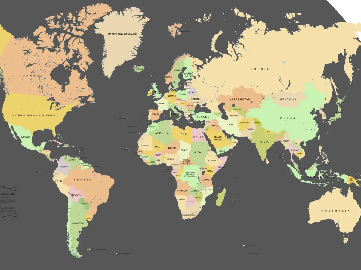
Greenland, the largest island in the world, is making headlines once again. Donald Trump is repeating the "need" to have Greenland, citing its role in ensuring the security and safety of his country. It is located between North America and Russia, making it a strategic point for the US. "We do need Greenland, absolutely. We need it for defence," Trump said on Sunday. Besides what Trump says about defence, it is also rich in minerals, and is an autonomous territory of the Kingdom of Denmark. After what happened in Venezuela, Trump's assertion of the need to take control of Greenland has caused panic. Meanwhile, all this talk has led the common man to check out Greenland. People are also wondering how big this island really is. If you look at a map, it appears as big as a country, and even a continent. It covers an area of 836,000 square miles. Seems huge? Well, it isn't really.
Greenland can appear big on flat maps, but its true size is mostly reflected in the globe. Rolling out a sphere on a flat, two-dimensional surface changes a lot of things. The shape of land masses is altered, and you also cannot tell the true size. This is the problem that has led many people to think Greenland is quite big when it is not. What is to blame for this erroneous projection is the map in use. The Mercator projection, the most common type of map in use today, changes Earth's latitudes and longitudes into straight lines.

Greenland size comparison with Australia, Africa and India
On the map, Greenland looks only a bit smaller than Africa. However, the continent is 14 times larger than the island. Australia is about 3.5 times bigger, and even India, which looks way smaller on a regular map, is roughly 1.5 times bigger than the island. This happens because of distortions in the map as you move further away from the equator. Fritz Kessler, a Penn State geography professor and map projection expert, told NPR that in mathematical terms, the parallels and meridians get pulled in different magnitudes from the equator to the poles, giving this exaggerated effect. This leads to the landmass falling in the upper latitudes appearing huge. There have been efforts to move away from the Mercator to other, more accurate maps, such as the Robinson projection.
Trending Stories
)
Historic first: ‘Ganga aarti’ performed on River Thames in London
)
China discovers vast gold and silver 'mine' in the Pacific with unheard-of deposits
)
China thinned Himalayan troop presence in 2025, India defence report says; terms border situation 'stable'
)
Who really benefits from the BRICS bank? Inside the New Development Bank's $43 billion portfolio
)
Turkish Airlines plane flies through a storm three times, triggering severe turbulence
)
‘Want to reset ties with India, have engagement based on mutual interests,’ says Bangladesh minister
)
Did India risk its US trade deal despite softer stance at BRICS?
)
Baba Vanga's first prophecy for 2027 is out, and straight out of science fiction
)
Nigerian Navy seizes 10,000 litres of suspected illegal fuel in Rivers State crackdown
)
Plane carrying prominent figure crashes at Libya’s Misrata airport: Report
)
Russia proposes to build 360 kmph Ivolga FG trains in India: What happened on sidelines of BRICS
)
Indian importers urge Bangladesh to lift export ban on 'Hilsa' fish ahead of Durga Puja
)
Scotland, Wales & Northern Ireland push for exit from UK | Race To Power
)
Saudi Arabia discovers 110 million tonnes of Uranium-rich ore in Madinah region
)
Extreme warming in Indian Ocean added 695 billion tons of ice to Antarctica ice sheet
)
US court blocks Trump administration move ending automatic H-4 EAD extensions for seven spouses
)
Liam Neeson sparks romance rumours after holding hands with Stella Stocker at TIFF 2026
)
Trump downplays China's alleged 'help' to Iran in strike on Jordan base | Gravitas
)
Photographs, LeT labels vanish from two 2008 Mumbai attack entries in Pakistan’s most wanted list
)
Meghan Markle shares first glimpse of family life with Prince Harry and children in UK
)
Pakistan puts Pak Rs 70 lakh bounty on UN terrorist Masood Azhar; move draws skepticism in Delhi
)
Woman removes all her clothes on American Airlines flight, performs 'indecent acts'; arrested
)
Ecstasy tablets are rage in 'drug haven' Libya | Gravitas
)
Iran, India agree to deepen humanitarian and political ties, President Pezeshkian says
)
‘Let’s go’: Newly declassified videos show dramatic rescue of US Air Force officers downed in Iran
&im=FitAndFill=(700,400))
New OTT releases this week (September 14-20, 2026): Lust Stories 3, Waiting Hai, Irumudi- 5 new titles coming on Netflix, Prime Video and more
)
'Huge destructive power': North Korea calls its latest missile launches 'live-fire drill' even as US dismisses 'immediate threat'
&im=FitAndFill=(700,400))
Why Chinese PL-15 air-to-air missiles use dual-pulse motors compared to European interceptors
)
Video of Pakistani lawmaker struggling to read English tribute to Jinnah goes viral - WATCH
)
‘US ensuring global energy supplies’: Trump demands reimbursement for securing Strait of Hormuz
)
Sent home midway from UK tour, Pakistan's Salman Agha hits 300* in domestic return
)
'Now Trump is copying us': Shivakumar links US $5,000 plan to Congress guarantees
&im=FitAndFill=(700,400))
Why European Meteor missiles use ramjet engines compared to standard US solid rockets
)
UK man admits drugging, raping wife for 20 years in shocking abuse case
)
800 million years old - Scientists discover 'fingerprints' of supercontinent Gondwana in ancient rocks
Donald Trump and the Greenland problem
Trump got the US military to capture Venezuela’s President Nicolas Maduro over the weekend, leading to widespread condemnation from world leaders. This triggered fears that his previous calls to control Greenland could lead to similar forcible action on the island as well. European leaders have come together to work on a plan in the event that Trump tries something. French Foreign Minister Jean-Noel Barrot told France Inter radio on Wednesday that they want to act against US moves “together with our European partners”. Meanwhile, Denmark’s Defence Ministry on Wednesday confirmed that its soldiers will “shoot first and ask questions later” if Trump decides to attack Greenland, based on a rule from 1952. The rule states that soldiers can “immediately” fight back if enemy forces invade, and it remains in force, the ministry told Berlingske, a centre-right newspaper in Denmark.

