India's Northeast faces forest crisis that its own agencies can’t explain | WION Exclusive

&imwidth=600&imheight=450&format=webp&quality=medium "India's Northeast faces forest crisis that its own agencies can’t explain | WION Exclusive")
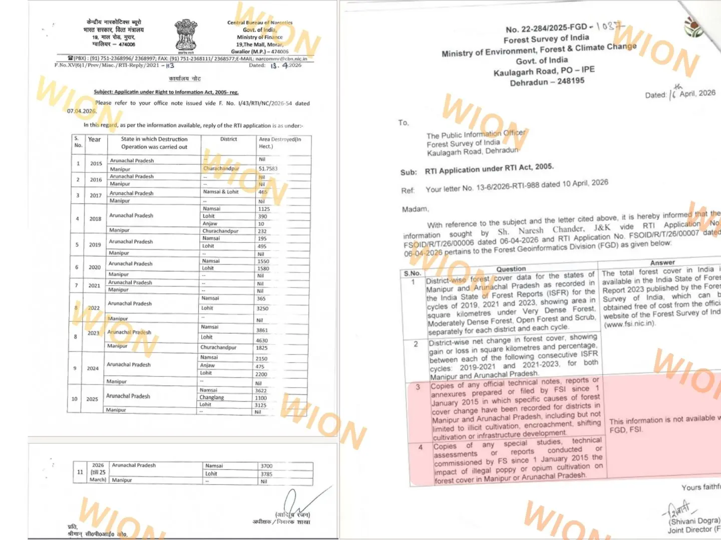
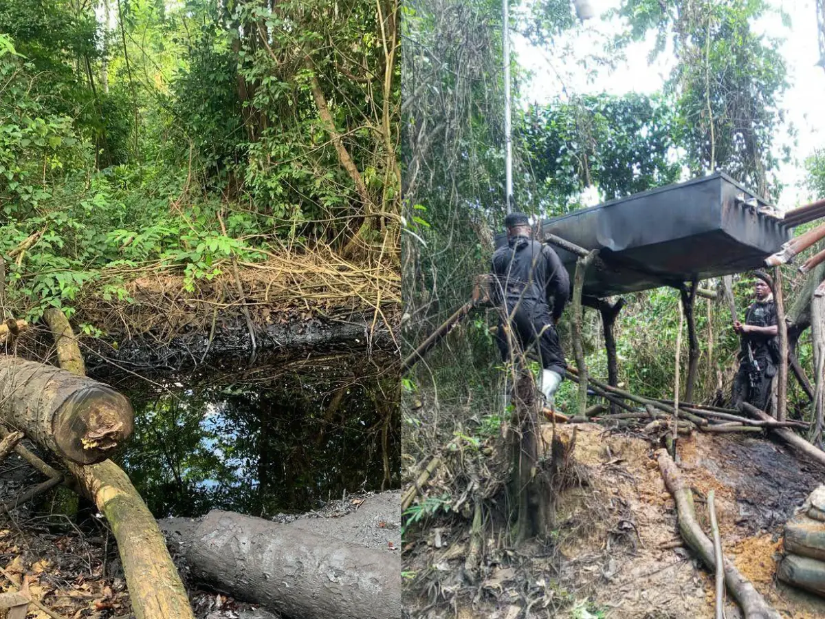
RTI replies received by WION from Ministry of Finance and Ministry of Environment (CBN), Forest and Climate Change (FSI Dehradun). Photograph: (WION)
This investigation follows Part One of WION’s report on the Northeast’s vanishing forests, which examined governance collapse, climate impacts and Manipur’s deforestation crisis.
In just the first three months of 2026, India’s Central Bureau of Narcotics (CBN) has destroyed 7,485 hectares of illegal poppy fields in two districts of Arunachal Pradesh - almost 16times the area it recorded when operations began in less than a decade ago. Yet the country’s premier forest‑monitoring agency, the Forest Survey of India (FSI) has no internal record of what is driving forest loss in the same region, and has never conducted a study on how illegal poppy cultivation is impacting the forests of Manipur and Arunachal Pradesh. The files WION accessed through Right to Information reveal a stark disconnect: India is meticulously tracking its narcotics war but is unaware when it comes to explaining a forest crisis unfolding in the region.
What the CBN data shows on the ground
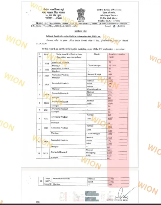
(Caption: Records of illegal Poppy fields destroyed by CBN between 2015 - 2026 accessed by WION via RTI)
The CBN’s reply to WION, issued from its Gwalior headquarters provides a rare, year‑wise and district‑wise window into the scale of poppy eradication operations in the Northeast from 2015 to March 2026. For Arunachal Pradesh, the table starts with “Nil” destruction in 2015 and 2016, then records 465 hectares of poppy fields destroyed in Namsai and Lohit districts in 2017 - the first time significant operations appear in the official record.
From there, the escalation is steep. In 2018, CBN records 1,525 hectares destroyed across Namsai, Lohit and Anjaw; in 2020, operations in Namsai and Lohit alone cover 3,130 hectares. By 2023, the destruction area peaks at 8,491 hectares in Arunachal Pradesh, with Namsai and Lohit again at the centre of the map, confirming them as persistent epicentres of the state’s narcotics‑linked cultivation.
Trending Stories
&im=FitAndFill=(700,400))
&im=FitAndFill=(700,400))
&im=FitAndFill=(700,400))
)
&im=FitAndFill=(700,400))
)
)
)
)
)
&im=FitAndFill=(700,400))
)
)
)
)
)
)
)
)
)
)
)
)
)
)
)
)
)
)
&im=FitAndFill=(700,400))
)
)
)
The most recent figures are even more striking. CBN operations in Arunachal Pradesh in 2025 covered 7,847 hectares across Namsai, Changlang and Lohit - a figure that not only confirms but exceeds earlier public estimates for that year. In 2026, with data recorded only up to 25 March, the bureau already reports 7,485 hectares of poppy fields destroyed in Namsai and Lohit, putting the state on course to surpass every previous annual total if the pace continues through the year.
Manipur presents a very different pattern in the CBN’s own records. The table shows destruction operations only in Churachandpur district in three years - 51.7583 hectares in 2015, 232 hectares in 2018 and 1,825 hectares in 2023 - with every other year from 2016 to 2026 marked as “Nil” for the state. This suggests that either poppy eradication in Manipur is being handled primarily by state agencies outside CBN’s mandate, or that central‑level documentation of narcotics‑linked clearance there is far thinner than in Arunachal, despite Manipur’s documented forest losses and its proximity to Myanmar’s opium‑producing belt.
Inside FSI’s data vacuum
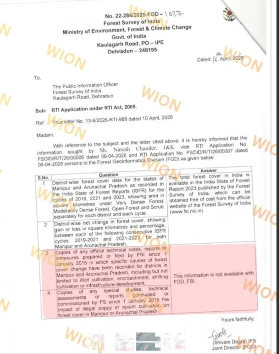
(Caption: FSI says no information related to causes of Forests loss in Northeast available - Section 3 and 4 (RTI) and for available data it directs to already publicly available data on its website.)
If the CBNtable shows how precisely India can track narcotics operations when it chooses to, the Forest Survey of India’s RTI reply reveals how little institutional attention is being paid to the drivers of forest loss in the same states. Responding on 16 April 2026 to WION’s questions to its Forest Geoinformatics Division (FGD), FSI was asked to provide district‑wise forest cover data for Manipur and Arunachal Pradesh for the 2019, 2021 and 2023 India State of Forest Report (ISFR) cycles, broken down by forest density class.
Instead of supplying the requested tables, the FGD pointedthe applicant to the publicly available ISFR report on its website. FSI states: “The total forest cover in India is available in the India State of Forest Report 2023 published by the Forest Survey of India, which can be obtained free of cost from the official website of the Forest Survey of India (www.fsi.nic.in).” The follow‑up question on district‑wise net change in forest cover between the 2019-2021 and 2021-2023 cycles carries no specific numerical answer, leaving the RTI request for structured, district‑wise change data effectively unaddressed.
It is the response to the third and fourth questions, however, that most starkly exposes the data gap. Asked for “copies of any official technical notes, reports or annexures… in which specific causes of forest cover change have been recorded for districts in Manipur and Arunachal Pradesh”, FSI’s Forest Geoinformatics Division replied: “This information is not available with FGD, FSI.” In the corresponding row for “special studies, technical assessments or reports… on the impact of illegal poppy or opium cultivation on forest cover in Manipur or Arunachal Pradesh”, no study is cited and no document is provided, amounting to a confirmation that no such work is on record with the division.
A state that counts trees, not causes
Taken together, the two RTI responses show a state apparatus that is counting some things very closely - and almost entirely ignoring others. On one side, a narcotics enforcement agency can produce a signed, stamped table with annual figures down to the last decimal of a hectare, broken by district, for more than a decade of poppy destruction operations in Arunachal Pradesh and Manipur. On the other, the government body responsible for mapping India’s forests cannot provide basic district‑wise tables under RTI and has no internal record of what is driving the very forest losses its own published reports document in Manipur and Arunachal.
This disconnect has consequences beyond paperwork. Without internal notes that link forest‑cover changes to specific drivers - such as illicit cultivation, encroachment, infrastructure or climatic factors - FSI cannot, on its own records, explain why forests in some of India’s most sensitive ecological and geopolitical regions are thinning. That gap reinforces the concern raised in Part One of this series: that India’s forest‑governance system has become adept at counting and classifying tree cover, but far less capable of understanding the deeper governance failures and land‑use shifts that are hollowing out the Northeast’s green cover from within.
It also speaks to a broader institutional blind spot. Community leaders and experts from the region have long warned that treating forests as mere canopy percentages - divorced from the Indigenous governance systems, livelihoods and pressures on the ground - creates a policy regime that is blind to both the causes and the lived consequences of ecological breakdown. The RTI files now show that this blindness extends into the state’s own knowledge systems: the division tasked with geospatial forest monitoring does not maintain internal documentation on what its maps are actually showing in two of the country’s most affected states.
Why this matters for Manipur and Arunachal
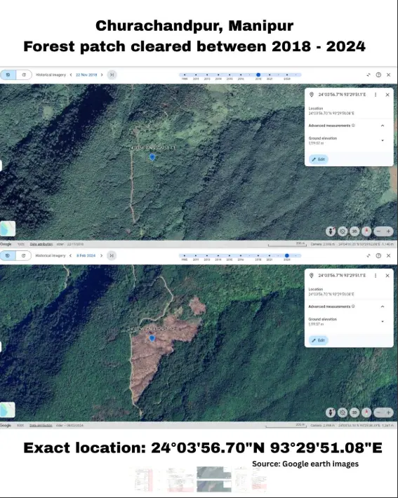
(Caption: Forest patch cleared between 2018-2024 (Image verified via Google earth historical images)
For Arunachal Pradesh, the overlap between the CBN data and documented forest loss is impossible to ignore. The same districts that have emerged as centres of narcotics‑driven cultivation in the CBN’s 2017-2026 table - especially Namsai and Lohit, with Changlang and Anjaw entering later - also sit within a wider pattern of forest fragmentation and land‑use change already flagged by independent analyses and satellite imagery. The official confirmation that thousands of hectares are being cleared and then destroyed as poppy fields each year raises uncomfortable questions about how much of this churn is captured, and correctly interpreted, in forest‑cover assessments that do not track causes.
In Manipur, the contradictions are sharper still. The state has recorded some of the highest regional forest losses in recent ISFR cycles, and former chief minister N Biren Singh has publicly and repeatedly linked that loss to a “rapidly expanding network” of illegal poppy cultivation, insurgent finance and cross‑border trafficking along the Indo‑Myanmar frontier. At the same time, the CBN’s own table records operations only in Churachandpur in 2015, 2018 and 2023, leaving large parts of Manipur’s poppy belt and deforestation hotspots invisible in central narcotics data. When this is set against FSI’s admission that it has no internal documentation on causes of forest cover change in Manipur, the picture that emerges is of a state fighting a live ecological and security crisis without a shared, integrated evidence base.
The satellite imagery currently being examined by WION - showing patchwork clearances and expanding bare patches across districts like Tengnoupal and Pherzawl - only underscores how quickly ground realities are changing compared to the static, siloed way in which data is being collected and stored. While enforcement agencies measure raids and destroyed fields, and forest agencies report net cover in aggregated categories, no institution appears to be officially connecting these dots in a way that can guide long‑term policy and accountability.
The next questions
The RTI trail opened by these two replies is only a flash point. The larger question is whether India is willing to break out of its current data silos. CBN’s tables show that the state can track illegal poppy cultivation with remarkable precision when enforcement is prioritised. FSI’s reply shows that the same precision has not been applied to understanding why forests are disappearing in some of the country’s most fragile landscapes, or to assessing the ecological impact of those very poppy fields on forest structure, water systems and communities. As the Northeast’s forests thin out, and the climate and security stakes rise, India must decide whether it will continue to count trees and poppy fields in isolation - or finally build an integrated picture that can explain, and help reverse, a crisis its own data currently cannot.
About the Author
