Mercator projection: Intentional deception or a navigation necessity?

&imwidth=600&imheight=450&format=webp&quality=medium "Mercator projection: Intentional deception or a navigation necessity?")
Mercator projection: Intentional deception or a navigation necessity?
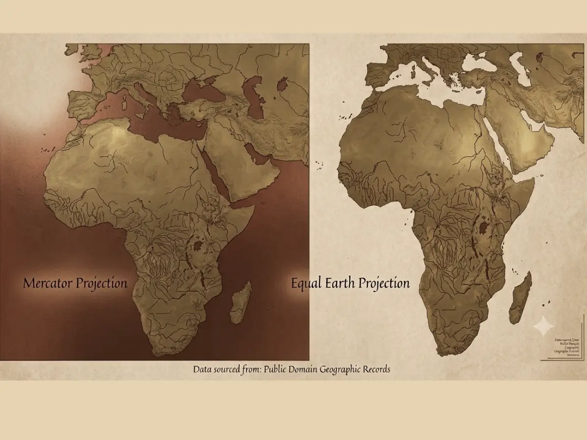
The UN General Assembly has backed a non-binding resolution encouraging the use of the Equal Earth map projection to better represent the true size of continents, especially Africa. The Togo-led resolution won 164 votes, with the US opposing and six countries abstaining
Correct the map: The title of the United Nations non-binding resolution adopted on Fri (Sep 4) by the General Assembly, aimed at encouraging governments, schools, media organisations and other institutions to consider using the Equal Earth projection. For sometimes now, the push for actual proportions of the world’s landmasses to be prevented more accurately had been foremost, specially for African countries.
What is Mercator projection and the problem with it?
The Mercator projection, which was developed by Flemish cartographer Gerardus Mercator in 1569, had greatly underrepresented African continent and some part of Asia, though it was primarily designed as a navigational tool for sailors, but distorts the size of landmasses, particularly as they move farther from the Equator. The Mercator projection gave Europe and North America a much greater visual presence, while reducing the apparent size of Africa, Latin America and parts of Asia, while in reality Africa covers approximately 30.3 million square kilometres, making it the second-largest continent after Asia, which spans roughly 44 to 45 million square kilometres.
Togo introduced the resolution on behalf of the African Group and supported by the African Union, it got approval from 164 countries, while the United States voted against it and six countries abstained.
Though the resolution is not binding, African countries and others that supported the resolution, argue that correcting the visual distortion could have implications beyond geography, particularly in education and perceptions of the continent’s importance and scale. Togo, leading the African push, has already moved towards updating its educational geography materials to incorporate the Equal Earth projection, while France has also indicated plans to move away from the traditional Mercator representation. This United Nations General Assembly resolution vote will encourage the use of the Equal Earth global map projection, that was invented in 2018 Bojan Šavrič, Bernhard Jenny, and Tom Patterson.
Trending Stories
&imwidth=280&imheight=210&format=webp&quality=medium)
&imwidth=280&imheight=210&format=webp&quality=medium)
&imwidth=280&imheight=210&format=webp&quality=medium)
&imwidth=280&imheight=210&format=webp&quality=medium)
&imwidth=280&imheight=210&format=webp&quality=medium)
&imwidth=280&imheight=210&format=webp&quality=medium)
&imwidth=280&imheight=210&format=webp&quality=medium)
&imwidth=280&imheight=210&format=webp&quality=medium)
&imwidth=280&imheight=210&format=webp&quality=medium)
&imwidth=280&imheight=210&format=webp&quality=medium)
&imwidth=280&imheight=210&format=webp&quality=medium)
&imwidth=280&imheight=210&format=webp&quality=medium)
&imwidth=280&imheight=210&format=webp&quality=medium)
&imwidth=280&imheight=210&format=webp&quality=medium)
&imwidth=280&imheight=210&format=webp&quality=medium)
&imwidth=280&imheight=210&format=webp&quality=medium)
&imwidth=280&imheight=210&format=webp&quality=medium)
&imwidth=280&imheight=210&format=webp&quality=medium)
&imwidth=280&imheight=210&format=webp&quality=medium)
&imwidth=280&imheight=210&format=webp&quality=medium)
&imwidth=280&imheight=210&format=webp&quality=medium)
&imwidth=280&imheight=210&format=webp&quality=medium)
&imwidth=280&imheight=210&format=webp&quality=medium)
&im=FitAndFill=(700,400)&imwidth=280&imheight=210&format=webp&quality=medium)
&imwidth=280&imheight=210&format=webp&quality=medium)
&im=FitAndFill=(700,400)&imwidth=280&imheight=210&format=webp&quality=medium)
&imwidth=280&imheight=210&format=webp&quality=medium)
&imwidth=280&imheight=210&format=webp&quality=medium)
&imwidth=280&imheight=210&format=webp&quality=medium)
&imwidth=280&imheight=210&format=webp&quality=medium)
&imwidth=280&imheight=210&format=webp&quality=medium)
&imwidth=280&imheight=210&format=webp&quality=medium)
&imwidth=280&imheight=210&format=webp&quality=medium)
&imwidth=280&imheight=210&format=webp&quality=medium)
The equal Earth map projection are simple to implement and fast to evaluate. Surely the Equal Earth projection will rebalance global cartography and promote equitable representation of the world’s regions, we know some school of thought believe African continent is large enough to contain the contiguous United States, China, India and much of Europe within its borders, with land still remaining.
Analysts believe actual presentation and representation will not only help schools, media organisations and other institutions follow the actual Cartography, but also cut out error, such as the one made by US State Department in Rio de Janeiro in July 2026 during the International AIDS conference, where all six highlighted African nations were mislabeled and misplaced.
