5 times in 40 years: Rare Atlantic Niña could soon grip Earth as Super El Niño tightens its jaws. What to expect?

&imwidth=600&imheight=450&format=webp&quality=medium "5 times in 40 years: Rare Atlantic Niña could soon grip Earth as Super El Niño tightens its jaws. What to expect?")
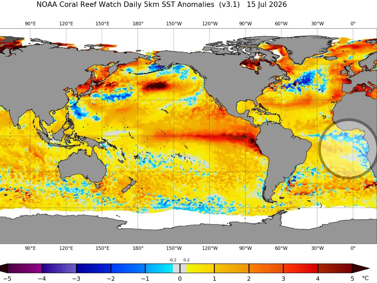
Atlantic Nina is brewing in the Atlantic Ocean and can lower the number of cyclones and hurricanes in 2026. Photograph: (NOAA)
A rare Atlantic Nina has joined forces with the Super El Niño in 2026. So the Pacific waters are warm, and portions of the Atlantic are cooler. Here is how it will affect the hurricane season in the US and the monsoon in India.
Even as El Niño wreaks havoc across the world, a rare Atlantic Niña is emerging in the tropics. The former has warmed the Pacific, while the latter, as the name suggests, is brewing in the Atlantic. It is different from La Niña, which is the opposite of El Niño. The National Oceanic and Atmospheric Administration (NOAA) released a sea surface temperature anomaly map, clearly showing the difference between what is happening in the Atlantic and the Pacific. The phenomenon causes sea surface temperatures to drop below average, but instead of the Pacific, it happens in the eastern equatorial Atlantic Ocean.
Experts say that if temperatures remain 0.5 degrees Celsius below average for two overlapping seasons, it will become the sixth Atlantic Niña of the last 40 years. The NOAA map shows El Niño stretching outward from the northeastern coast of South America, and the Atlantic Nina is off the southeastern coast of Africa. Even though the two work on opposite poles, they are in perfect alignment, says they are actually perfectly aligned in their atmospheric impact,” senior meteorologist Andrej Flis wrote in a piece for Severe Weather Europe.
How does Atlantic Nina affect weather?
According to NOAA, Atlantic Nina makes it harder for thunderstorms and tropical cyclones to form because the cooler waters cause a drop in the amount of heat and moisture needed to fuel convection. Expect half the number of tropical cyclones elsewhere, and hurricanes in the US, than an average year. This is similar to how El Niño works, which depletes the chances of storms turning into hurricanes. The forecast by NOAA for the 2026 Atlantic hurricane season includes eight to 14 named storms, three to six hurricanes, and one to three major hurricanes.
The effects are already visible. By July 17, at least two named storms had formed in the Atlantic Basin. But there is just Tropical Storm Arthur for now, which brought floods to the southern US in June. There is no hurricane on the horizon yet; however, the first one starts developing around August 11 in a year. There are two Atlantic disturbances, and one of them could develop into a cyclone in the next seven days. In conclusion, the presence of both El Niño and Atlantic Niña at the same time means a year with fewer hurricanes and cyclones.
Atlantic Nina effect on India
Trending Stories
&imwidth=280&imheight=210&format=webp&quality=medium)
&imwidth=280&imheight=210&format=webp&quality=medium)
&imwidth=280&imheight=210&format=webp&quality=medium)
&imwidth=280&imheight=210&format=webp&quality=medium)
&imwidth=280&imheight=210&format=webp&quality=medium)
&imwidth=280&imheight=210&format=webp&quality=medium)
&im=FitAndFill=(700,400)&imwidth=280&imheight=210&format=webp&quality=medium)
&imwidth=280&imheight=210&format=webp&quality=medium)
&imwidth=280&imheight=210&format=webp&quality=medium)
&imwidth=280&imheight=210&format=webp&quality=medium)
&imwidth=280&imheight=210&format=webp&quality=medium)
&imwidth=280&imheight=210&format=webp&quality=medium)
&imwidth=280&imheight=210&format=webp&quality=medium)
&imwidth=280&imheight=210&format=webp&quality=medium)
&imwidth=280&imheight=210&format=webp&quality=medium)
&imwidth=280&imheight=210&format=webp&quality=medium)
&imwidth=280&imheight=210&format=webp&quality=medium)
&imwidth=280&imheight=210&format=webp&quality=medium)
&imwidth=280&imheight=210&format=webp&quality=medium)
&imwidth=280&imheight=210&format=webp&quality=medium)
&imwidth=280&imheight=210&format=webp&quality=medium)
&imwidth=280&imheight=210&format=webp&quality=medium)
&imwidth=280&imheight=210&format=webp&quality=medium)
&im=FitAndFill=(700,400)&imwidth=280&imheight=210&format=webp&quality=medium)
&imwidth=280&imheight=210&format=webp&quality=medium)
&imwidth=280&imheight=210&format=webp&quality=medium)
&imwidth=280&imheight=210&format=webp&quality=medium)
&imwidth=280&imheight=210&format=webp&quality=medium)
&imwidth=280&imheight=210&format=webp&quality=medium)
&imwidth=280&imheight=210&format=webp&quality=medium)
&imwidth=280&imheight=210&format=webp&quality=medium)
&imwidth=280&imheight=210&format=webp&quality=medium)
The phenomenon has an inverse relationship with the Indian Summer Monsoon Rainfall (ISMR). A cooler Atlantic means stronger monsoon rains in India. Initially, the India Meteorological Department (IMD) forecast below-normal to uneven rainfall nationwide for July 2026; conditions have led to severe, extremely heavy rain events across multiple states. Heavy rainfall is predicted for many northern, eastern and central states during the active monsoon phase till July 20. Ladakh recorded 65% more rainfall than normal as of mid-July.

