ISRO satellite captures monsoon clouds blanketing 95% of India; IMD issues rain alert

&imwidth=600&imheight=450&format=webp&quality=medium "ISRO satellite captures monsoon clouds blanketing 95% of India; IMD issues rain alert")
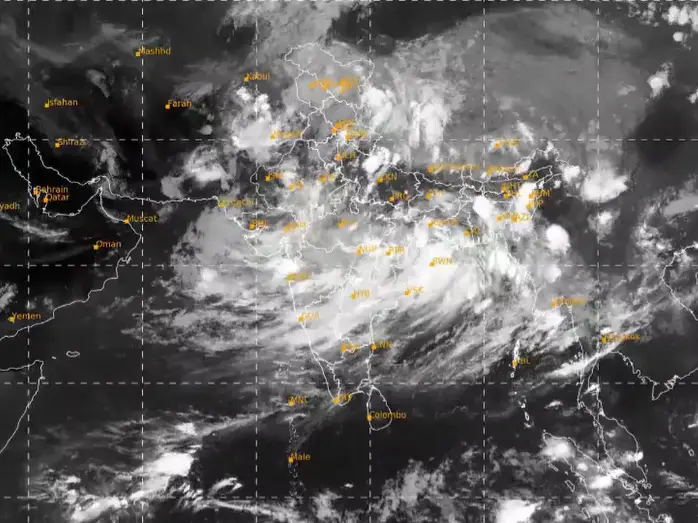
Southwest monsoon covered wider part of the country. Photograph: (X/@Indiametdept)
The Southwest Monsoon supplies about 75 per cent of India's annual rainfall, crucial for irrigation, drinking water, and hydropower. It begins in early June over Kerala and covers most of India by mid-July.
The Indian monsoon has returned across the nation in full swing after a brief seasonal lull. Following the development, the India Meteorological Department (IMD) has released several images showing heavy clouds blanketing the entire country. The image was captured by ISRO's advanced INSAT-3DS weather satellite, which was recorded on July 22, 2026, between 3:00 PM and 3:27 PM Indian Standard Time (IST).
"Active monsoon Conditions likely over northwest, central and adjoining north peninsular India, east and northeast India during next 3-4 days," the IMD said in a press release. The released thermal infrared image shows a curved cloud band stretching from the northern Bay of Bengal, moving across Odisha, Chhattisgarh and Madhya Pradesh, before extending towards Gujarat and the Arabian Sea.
IMD explained," Different types of clouds reflect in different amounts based on their physical properties like the amount and size of raindrops/ice crystals and their density. Cumulonimbus clouds appear brightest. Thick (low / medium) clouds like cumulus, stratus, stratocumulus appear comparatively brighter than the thin (Higher) clouds like cirrus. Sea surface appears darker in this imagery."
Earlier climate models have predicted a below-normal southwest monsoon for 2026; however, wider parts of the nation are currently showing overcast skies with the expectation of widespread rainfall.
IMD's rain forecast
Trending Stories
&imwidth=280&imheight=210&format=webp&quality=medium)
&imwidth=280&imheight=210&format=webp&quality=medium)
&imwidth=280&imheight=210&format=webp&quality=medium)
&imwidth=280&imheight=210&format=webp&quality=medium)
&imwidth=280&imheight=210&format=webp&quality=medium)
&imwidth=280&imheight=210&format=webp&quality=medium)
&imwidth=280&imheight=210&format=webp&quality=medium)
&imwidth=280&imheight=210&format=webp&quality=medium)
&imwidth=280&imheight=210&format=webp&quality=medium)
&imwidth=280&imheight=210&format=webp&quality=medium)
&imwidth=280&imheight=210&format=webp&quality=medium)
&imwidth=280&imheight=210&format=webp&quality=medium)
&imwidth=280&imheight=210&format=webp&quality=medium)
&im=FitAndFill=(700,400)&imwidth=280&imheight=210&format=webp&quality=medium)
&imwidth=280&imheight=210&format=webp&quality=medium)
&imwidth=280&imheight=210&format=webp&quality=medium)
&imwidth=280&imheight=210&format=webp&quality=medium)
&imwidth=280&imheight=210&format=webp&quality=medium)
&imwidth=280&imheight=210&format=webp&quality=medium)
&imwidth=280&imheight=210&format=webp&quality=medium)
&imwidth=280&imheight=210&format=webp&quality=medium)
&imwidth=280&imheight=210&format=webp&quality=medium)
&imwidth=280&imheight=210&format=webp&quality=medium)
&imwidth=280&imheight=210&format=webp&quality=medium)
&imwidth=280&imheight=210&format=webp&quality=medium)
&imwidth=280&imheight=210&format=webp&quality=medium)
&imwidth=280&imheight=210&format=webp&quality=medium)
&imwidth=280&imheight=210&format=webp&quality=medium)
&imwidth=280&imheight=210&format=webp&quality=medium)
&im=FitAndFill=(700,400)&imwidth=280&imheight=210&format=webp&quality=medium)
&imwidth=280&imheight=210&format=webp&quality=medium)
&imwidth=280&imheight=210&format=webp&quality=medium)
&imwidth=280&imheight=210&format=webp&quality=medium)
&imwidth=280&imheight=210&format=webp&quality=medium)
&imwidth=280&imheight=210&format=webp&quality=medium)
According to the IMD, widespread severe weather is expected between July 22 and July 24, with isolated areas likely to see heavy to very heavy rainfall across multiple regions. In particular, extremely heavy rain is forecast for isolated pockets of Jammu and Kashmir, Ladakh, southwest Madhya Pradesh, southeast Rajasthan, Konkan, and Goa.
This intense spell of rain will also impact central Maharashtra between July 22-23, before moving on to heavily saturate the Gujarat region between July 22-24. Meanwhile, rainfall activity is expected to remain relatively subdued over south Peninsular India over the coming week.
The Southwest Monsoon supplies about 75 per cent of India's annual rainfall, crucial for irrigation, drinking water, and hydropower. It begins in early June over Kerala and covers most of India by mid-July. The season is vital for crops like rice, cotton, and sugarcane, with delays or failures impacting food security, livelihoods, and the economy.

