'Blueprint of abuse': What the secret map of Epstein Island reveals

The document provides a rare "Site Plan" of Little St. James. With handwritten notes marking a "Heli House," "Tent," and "Observatory," the map reveals the calculated infrastructure of Epstein's private world.
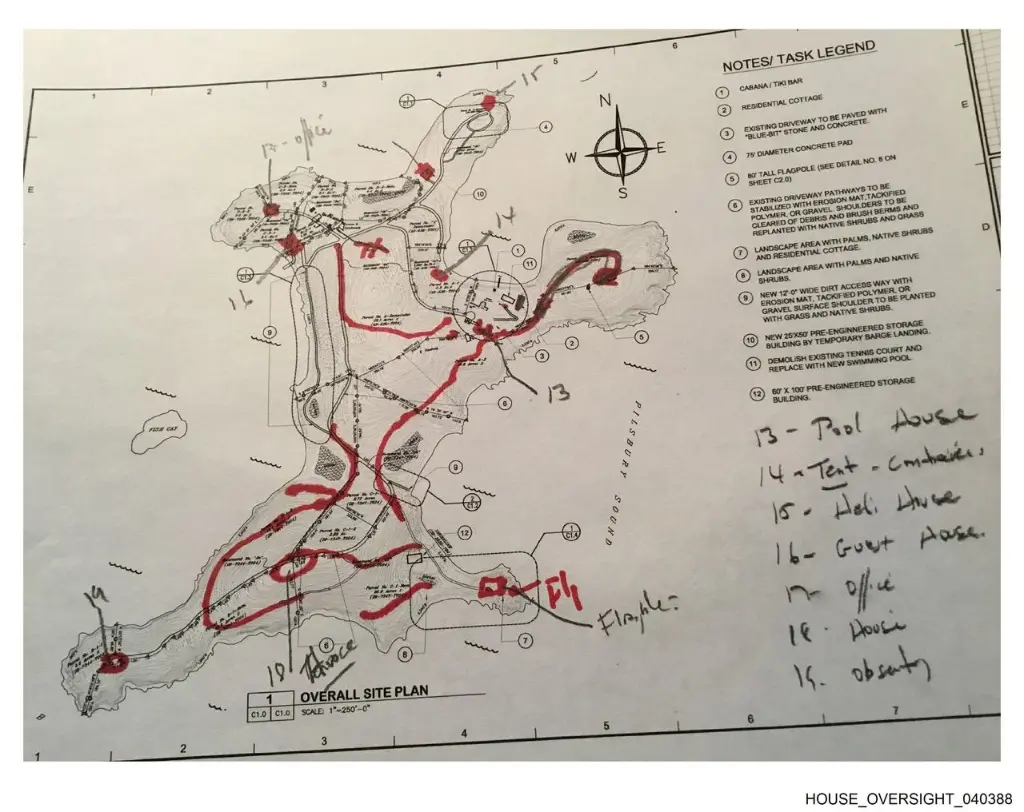
1. The Document:
This document is part of a batch of files released by Democrats on the House Oversight Committee, aimed at providing "transparency" into Jeffrey Epstein's crimes. The map, titled "OVERALL SITE PLAN," appears to be a logistical or construction document used to manage the island's operations. The "040388" stamp confirms it is now official evidence in the congressional investigation.

2. The "Heli House" (Note 15):
Handwritten note #15 identifies the "Heli House" located near the island's helipad. This was the primary arrival point for high-profile guests who flew in via helicopter to avoid customs and prying eyes at the main airport in St. Thomas. The map shows a direct red path connecting this arrival zone to the rest of the compound, ensuring guests could be whisked away immediately upon landing.

3. The "Tent - Contractors" (Note 14):
Perhaps the most telling detail is Note #14, labeled "Tent - Contractors." This suggests that labours or staff were housed in temporary structures, distinct from the luxury villas. This separation likely served a dual purpose: keeping workers available for 24/7 construction (like the "Pool House" referenced in Note 13) while segregating them from the illicit activities taking place in the main areas.

4. The "Guest House" vs. "House" (Notes 16 & 18)
The map clearly distinguishes between the "Guest House" (#16) and the "House" (#18), likely Epstein’s main residence. This separation allowed Epstein to host multiple groups of people, victims, recruiters, and wealthy associates, simultaneously but separately. The "Main House" is known to be where many of the abuses allegedly occurred, away from the other cottages.

5. The Isolated "Observatory" (Note 19)
Located at the far western tip of the island, connected by a long, winding red path, is Note #19: the "Observatory." This remote structure highlights the extreme privacy the island offered. Far removed from the main compound, it provided a secluded location that could be used for illicit purposes under the guise of "stargazing," or simply as another layer of isolation for guests.

6. The "Pool House" (Note 13): The Social Hub
Note #13 marks the "Pool House," a central feature of the estate. Financial records from Epstein’s estate show he owed nearly $40,000 for pool construction at the time of his death, confirming that this area was under constant development. The map shows this structure as a central hub, connected by red lines to the main residence and guest areas.

7. The "Red Lines": A Web of Control
The map is crisscrossed with thick red lines connecting every major structure. While they likely represent service roads, utility lines, or golf cart paths, they visually demonstrate the "web" of the island. The layout was designed to be a self-contained ecosystem where movement could be strictly controlled, ensuring that once someone arrived at the "Heli House," they were entirely within Epstein's grid.
)
)
)
)
)