On Earth Day, see terrifying before and after images of how climate change is affecting the planet

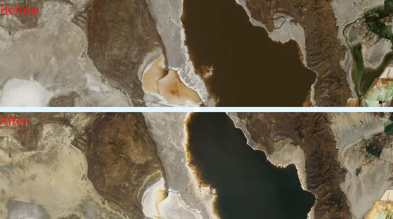
Image credit: NASA) Drying Lake Urmia, Iran June 3, 2021 - Nov. 23, 2021
Iran's Lake Urmia is one of the world's largest hypersaline (extremely salty) lakes. It has been declared a Wetland of International Importance and a UNESCO Biosphere Reserve. But as reported by the United Nations Environment Programme, its water level began to decline rapidly in the mid-1990s. Incoming water was diverted for agricultural use, dams blocked inflowing rivers, rainfall decreased, and rising temperatures brought increased evaporation. Torrential rains in 2018 and 2019 helped to replenish the lake, as seen in the June image, which shows Urmia largely filled with water tinted red by bacteria or algae. But by the time of the November image, the lake was once again drying out.
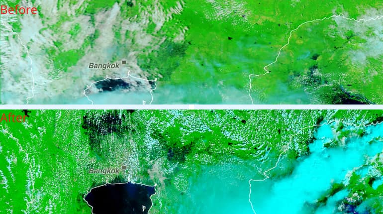
(Image: NASA) Flooding in Thailand Oct. 19, 2019 - Oct. 20, 2021
Heavy monsoon rains, following on the heels of tropical storms Dianmu and Kompasu, triggered landslides and flooding in Thailand in October 2021. According to Thailand's space agency, some 5,200 square miles (13,600 square kilometres) were inundated as of Oct. 19, affecting more than a million people. In these false-colour images, water appears dark blue or black, saturated (thoroughly soaked) soil is light blue, vegetation is bright green, bare ground is tan, and clouds are white or turquoise

(Image: NASA) Melting Glaciers Enlarge Lakes on Tibetan Plateau (1987-2021)
The Tibetan Plateau, home to tens of thousands of glaciers, is very sensitive to climate change. Water from melting glaciers has created hundreds of new lakes and enlarged existing ones, such as the main pair shown here. The 1987 image was taken when Dorsoidong Co (left) was still separated from Chibzhang Co by a thin strip of land. A greater abundance of suspended silt in Dorsoidong Co is likely responsible for the color difference. As the water in the two lakes rose, it eventually covered the barrier, merging the lakes by the time of the 2021 image
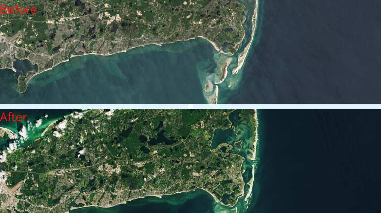
(Image: NASA) Cape Cod's Ever-Changing Coast (1984 - 2020)
The southeastern coast of Cape Cod, Massachusetts, changes constantly under the influence of currents, tides, waves, and storms. For example, in the 1984 image, the barrier spit (the long, narrow strip at the eastern edge) known as North Beach is unbroken. The Patriot's Day storm in 2007 cut an inlet through it, and the southern part became North Beach Island. Researchers have identified a cycle that repeats roughly every 150 years, in which the barrier is breached, regenerates, stretches southward, and is breached again. The lower islands, too, reform under the ever-changing conditions.
(Image: NASA) Record Low Water Level at Great Salt Lake, Utah (July 29, 2017 - July 24, 2021)
In July 2021, the southern portion of the Great Salt Lake in Utah reached its lowest average daily water level on record, according to the U.S. Geological Survey. The USGS notes that the water level in the southern part, which receives almost all the lake's inflow from rivers, is usually higher than in the northern part. These images show the decline in the northern part and a portion of the southern part over the last four years. The Union Pacific Railroad causeway separates the two parts. Organisms in the higher salinity northern part account for its different colour.
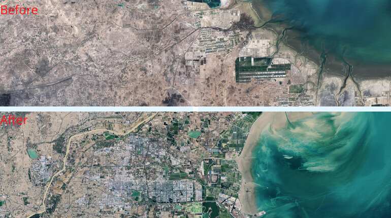
(Image: NASA) China's Changing Yellow River Delta (Feb. 13, 1989 - Oct. 24, 2020)
As China's Huang He (Yellow River) flows into the Yellow Sea, large amounts of sediment drop to the shallow seabed, building up a landform known as a delta. In 1996, Chinese engineers blocked the main channel, which had created the peninsula on the right of the 1989 image, forcing the river to veer northeast. By the time of the 2020 image, erosion and settling caused the tip of the old delta to retreat, while a new one formed to the north. At the same time, the population of the city of Dongying swelled from 378,000 in 1989 to 1.3 million in early 2021, with a corresponding increase in infrastructure
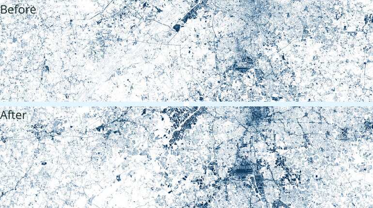
(Image: NASA) Great Migration" Back to Atlanta, Georgia (April 13, 1973 - May 6, 2020)
In a reversal of the "Great Migration" north of the early 20th century, people from the Northeast and Midwest have been moving to Atlanta, Georgia, making it one of the fastest growing metropolitan areas in the U.S. These false-colour images have been processed to emphasize the contrast between urban and forested or rural areas. Much of the new development visible in the 2020 image is relatively distant from downtown Atlanta.
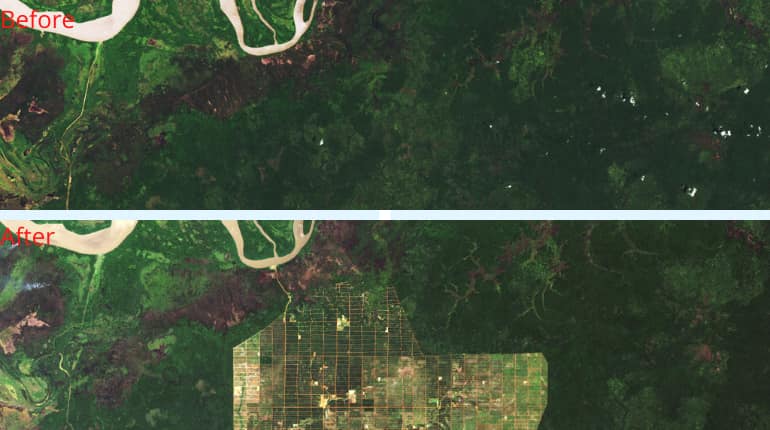
(Image: NASA) Deforestation in Papua, Indonesia (Nov. 20, 2002 - Nov. 27, 2019)
The 2019 image shows an area of Papua (also known as Western New Guinea) where the forest was cleared between 2011 and 2016, reportedly to make way for plantation agriculture.
The 2002 image was taken by the Thematic Mapper instrument on the Landsat 5 satellite. The 2019 image was taken by the Operational Land Imager on the Landsat 8 satellite.
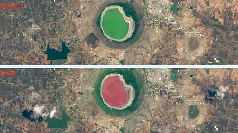
(Image: NASA) India's Lonar Lake Changes Colour (May 25, 2020 - June 10, 2020)
Over the span of a few days in June 2020, Lonar Lake in west-central India changed from green to pink. Warm, dry weather had evaporated a significant amount of the lake's water, leaving salts behind. Scientists speculate that with the increased salt concentration, a rapid rise in the numbers of salt-loving microorganisms caused the color change. A similar phenomenon happens periodically in Iran’s Lake Urmia and many Russian lakes when hot weather shrinks the lake and the water grows saltier.
)
)
)
)
)