New Year's Day quake stretched a Japanese peninsula coastline by over 800 feet

Japan coastline
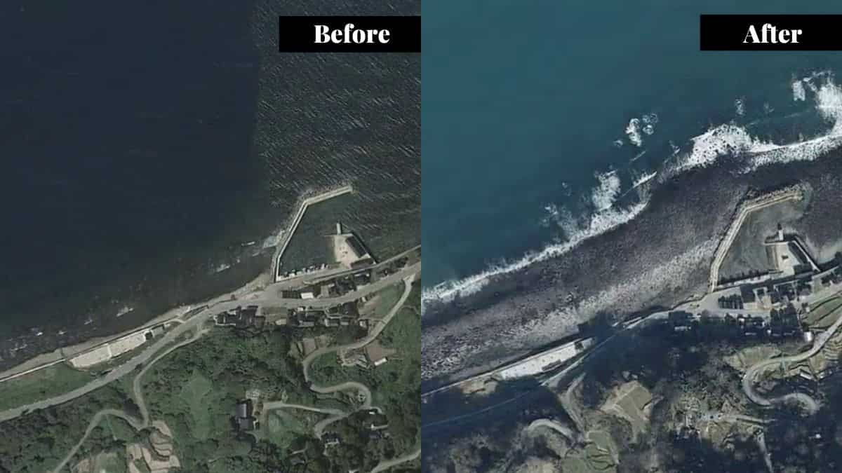
In the wake of the formidable New Year's Day earthquake, Japan's Noto Peninsula reportedly underwent a dramatic metamorphosis, which is vividly depicted in newly released satellite imagery. Theimages have captured some profound alterations to the Japanese coastline that now stands extended by up to 820 feet.
Striking images
Satellite snapshots, juxtaposing the landscape pre and post-quake, unveil the remarkable uplift effect that stretched the coastline by an impressive 820 feet (250 meters)—a span exceeding the length of two American football fields.
Shared on X (previously Twitter) by Nahel Belgherze, images show sections of the Noto Peninsula where the seafloor emerged above the waterline.
Posting a GIF of the images, Belgherze wrote: "The earthquake that struck Japan’s Noto peninsula on Monday was so strong that the coastline has moved up to 250 meters offshore due to significant land uplift."
Watch it here:
The earthquake struck Japan on January 1 at around 2:10 am EST (0710 GMT), registering a magnitude of 7.6. It triggered evacuations along the impacted coastal zones that witnessed a substantial uplift.
Scientists confirm uplift
Researchers from the Earthquake Research Institute at the University of Tokyo, conducting field investigations, reported findings of coseismic coastal uplift along the northwest coast of the Noto Peninsula. Notably, evidence was detected at ten locations, spanning from Kaiso to Akasaki sites.
Watch |Japan earthquake: One week later, quake-hit residents of a Japanese village live in limbo
"During a field investigation along the northwest coast of the Noto Peninsula, we found evidence at 10 locations, from Kaiso to Akasaki sites, of coseismic coastal uplift related to the Noto Peninsula Earthquake (M7.6)," said the researchers in a statement.
"The pattern of estimated coseismic coastal uplift appears to be decreasing southward from Kaiso to Akasaki," they added, as quoted by space.com.
The repercussions extended to Akasaki port, where nearly 14-foot-high (4.2 meters) tsunamiwreaked havoc, as indicated by water stains on building walls spotted during the university's field investigations.
Adding another layer to the comprehensive documentation of this geological event, Japan Aerospace Exploration Agency's (JAXA) Advanced Land Observing Satellite-2 (ALOS-2) offered a bird's-eye view of the coastal transformation.
By comparing coastline images from June 2023 to January 2, the satellite revealed significant seaward shifts in various areas, encompassing the Nafune port, Wajima city, and Minazuki bay, as outlined by the Geospatial Information Authority of Japan.
(With inputs from agencies)

