Turkey-Syria earthquake: Aerial shots from NASA satellites help in response, relief

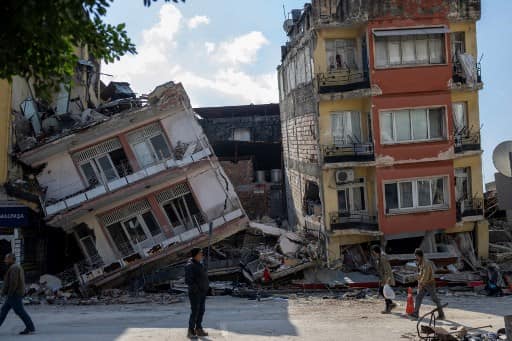
People walk next to damaged buildings in the Antakia historical city in Hatay.
With earthquakes ravaging Turkey and Syria earlier this week, the National Aeronautics and Space Administration (NASA) has been working to share aerial views and data from space in ways that could aid relief and recovery workers in the region, and also improve its ability to model and predict such events. According to a statement on Saturday (February 11), NASA Administrator Bill Nelson said, "NASA’s hearts and minds are with those impacted by the earthquakes in Turkey and Syria."
“NASA is our eyes in the sky, and our teams of experts are working hard to provide valuable information from our Earth-observing fleet to first responders on the ground,” Nelson added.
Proxy maps
The statement went on to say that one of the key capabilities of the American space agency is an expert with synthetic aperture radar, or SAR,which is used to measure how the ground moves and built landscape changes after this type of event (in this case, an earthquake).
ALSO READ |Turkey earthquake: Contractors detained over collapsed buildings; UN says toll may reach 50,000
"Scenes collected before and after the earthquake were used by a team of scientists from the Earth Observatory of Singapore and NASA’s Jet Propulsion Laboratory in Southern California to create something called a damage proxy map for Turkey. These maps compare before and after radar images of a given event to see how the landscape has changed," the statement added.
Such maps are made available to several organisations such as the World Bank, the Miyamoto Global Disaster Relief, the US State Department and the California Seismic Safety Commission. NASA said on Saturday that its members provide observations and maps via the Disaster Mapping Portal.
Lori Schultz, who is NASA's coordinator for this earthquake, said that the space agency takes seriously its obligation to support open science, and make information widely accessible.
"We don’t know everyone who is using this information or how, but we are fortunate to have heard back from a few groups. For instance, the World Central Kitchen – which is providing food to those who’ve been displaced – have let us know they make use of it," Schultz said.
Apart from assessing the damage, NASA is also using space- and ground-based observations to improve its ability to understand related events that cascade from the original natural disaster.
"By making use of data from the Commercial SmallSat Data Acquisition programme, which acquires observations from commercial satellites to help with NASA’s research goals, as well as from NOAA and international space agencies in Europe and Japan, scientists can spot areas that might be prone to increased landslide risks. Other satellites, such as Suomi-NPP and its nighttime lights observations can show the location of power outages," Saturday's statement said.
A new tool to assess the aftermath of an earthquake
NASA is hoping to add a new tool to assess the aftermath of an earthquake. It said on Saturday that Earth Surface Mineral Dust Source Investigation (EMIT) was launched to the International Space Station in July 2022. "As part of its observations of the composition of the material in Earth’s atmosphere, it can assess methane emissions," NASA said.
The EMIT's observations, times and locations are dictated by the station’s orbit. However, when passing over an earthquake site, measurements of increased or new emissions could point to events not otherwise easily spotted from space.
Turkey-Syria quake: Death toll passes 33,000
More than 33,000 people have died due to the earthquakes, and the United Nations expects the toll to at rise to 50,000. The UN also warned that at least 870,000 people urgently need hot meals acrossTurkeyand Syria.
WATCH WION LIVE HERE
You can now write for wionews.com and be a part of the community. Share your stories and opinions with us here.