A 'ghost city' sits in the middle of the Pacific Ocean. Aerial images now reveal what's it like

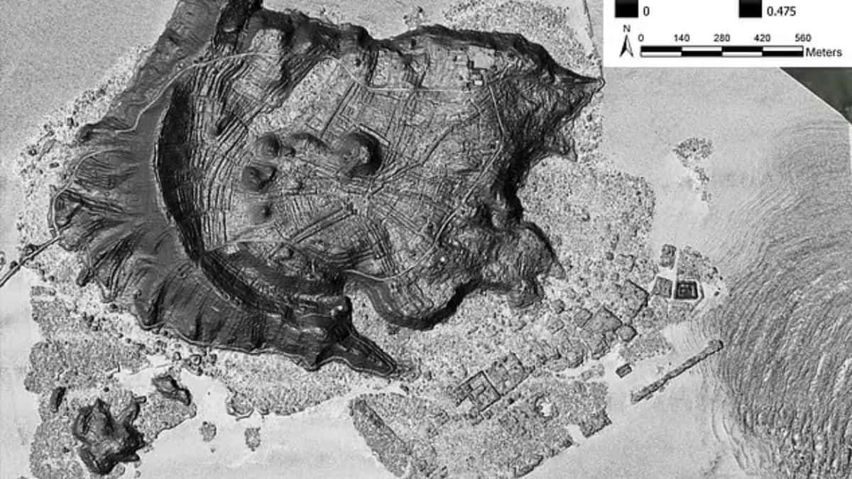
Image of lost city Nan Madol captured by aerial survey via LiDAR.
The precision-laser aerial surveys have revealed how advanced was the ghost city of Nan Madol when it existed and how it now sits hidden in the middle of the Pacific Ocean.
Also known as 'the Venice of the Pacific', this megalithic stone city has sometimes been compared to mythic Atlantis and now researchers are putting all their energy into uncovering the ruins of Nan Madol as they adopt plans to preserve it as aUNESCO World Heritage Site.
The aerial surveys, which have been conducted using LiDAR or 'Light Detection and Ranging' laser-mapping, uncovered "a sophisticated and extensive landscape of cultivation features hidden under Temwen Island's vegetation."
This discovery is rewriting the history of Pacific Island cultures and explaining how societies, which were believed to have depended on natural tropical bounty and subsistence fishing, actually engaged in sophisticated agricultural planning.
The international team of researchers noted that "LiDAR can reveal whole archaeological landscapes hidden under heavy vegetation. That has led to its comparison withradiocarbon datingas a groundbreaking technological advance in archaeology."
Here's what researchers found in ghost city
Scientists, headed byBaltimore's Cultural Site Research and Management (CSRM) Foundation, mapped a network of irrigation terraces which once supplied freshwater across Nan Madol and in its dense tropical foliage where more ruins remain hidden.
Archaeologists believe that Nan Madol was a prominent city from 1100 to1628 AD and its decline started with the fall of the local Saudeleur monarchs in the 17th century.
Head of the project Dr. Douglas Comer said, "The consensus among archaeologists has been that there was no intensification of agriculture in Micronesia by means of formal field systems."
Dr Comer's team, while working with the local College of Micronesia, along with Stanford,Sandia National Laboratories and others, has questioned the older notions on which culture thrived onfermented 'breadfruit' (Artocarpus altilis).
Also Read:26,000-year-old human, animal footprints unearthed in Spain. It once was a settlement of...
In a US State Department release, he said that an "amazingly complex system of irrigated fields covering Temwen island" hinted at the existence of early and sophisticated taro root farming.
"The Temwen system also bears a resemblance to some Polynesian terracing systems, including the Kohala field system on Hawaii Island," stated his team in the journalRemote Sensingin 2019, further saying "and recently described slope terraces on Tutuila in American Samoa."
"Such complexity is in accord with what is observed in the LiDAR images of Temwen," he said.
(With inputs from agencies)